| |
| |
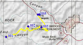
CR258 Radium King
Road s(u)
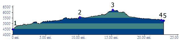
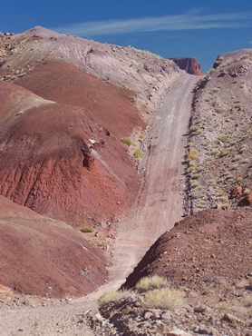
Sometimes elevation profiles
contain so much noise, it's hard to tell where the
ups and downs are. And at other times there are so
many small rollercoaster dips and rises, that the
elevation profile looks like it contains too much
noise. The one below is one of the latter. It may
take substantially more effort to ride this track
than one might suspect just from the difference
between low and high points.
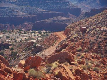
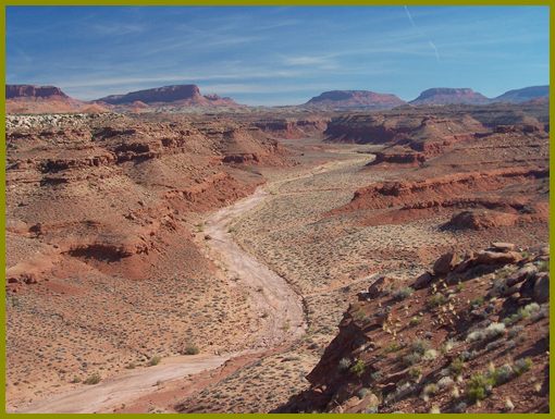
This is a grand tour of the Chinle formation. As the name of the road suggests (which is not found on local road signs, but appears in Gazetteer maps), this formation is the prime source of radioactive minerals in the Utah grand geologic catalog. As the formation tilts upwards, so does the road, but not without taking in every turn on every edge of the north side of Red Canyon, and not without leading over every outcrop of Chinle it can find. Sand on the route is often a function of the rocks the track goes through. There is little, if any sand on the whole route, save for the occasional dry wash crossing.
From West. To the best of my knowledge
the only option is to approach the starting point
of the profile from above, that is by going down
Ut276 towards Glen Canyon, then taking a right
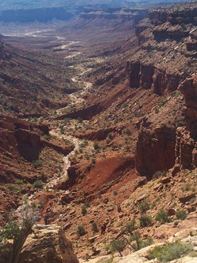
onto dirt road CR259 Red Canyon Road. Following
the latter down canyon to its junction with CR258
is every bit as scenic and interesting as the
summit that starts from there. This stretch down
Red Canyon Road may seem much longer than
estimated on the map, due to the road following
every twist and turn of the canyon. I thought I
had missed the turnoff for sure, when I saw an
elegantly understated plastic rod sticking out of
the red dirt, on it a single small number, the
customary San Juan county road sign. You have to
look closely to see the CR258 part.
A steeply climbing track seems to hop over every
lump of the Chinle formation it can get its road
bed on. Already at the first mine the road has
made up all of the elevation drop that CR259 lost
to get from its rim to the bottom of the canyon.
From here on the elevation of the Chinle formation
determines the elevation of the road, as the road
always heads for the next major outcrop.
Eventually the roller coaster double track meets
an open functioning mine, and the road becomes a
modern mine access road. I didn't see any trucks,
but the road bed is hard medalled and as smooth as
it gets, making progress much faster from here on.
Even though the profile indicates a last steep
climb to the planar mesa summit, this is actually
accomplished much faster than the previous
miniature roller coaster climbs, that don't really
show up on the profile. At the top the view shed
changes to more red canyons to the north.
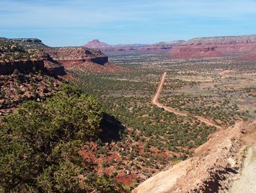
From South. (described downwards) The
first thing I noticed in the new view shed was how
close the landmark "Bears Ears" were. I was
actually not that far from where I had started the
ride at the jct between Ut276 and Ut95, but the
descent would take me further away from that point
again. Down in the valley stands a pole of a
monument. From up here pillow like sandstone slabs
make an interesting foreground. The road contours
along a regular series of mesas, named the "tables
of the sun". These were also part of the scenic
menu as backdrop, while coming down CR259. But
instead the twisting road takes us to the the
valley in the north, and CR259 dives down to it
with a few curves. Now heading towards the
north-west, a fast road, straight as an arrow,
leads to the intersection with Ut95 in a place
named Frye. I am not exactly sure what the name
Frye designates, either a trailer park or a
trailer storage facility. Nearby is also a closed
business of some kind. Looking for this
intersection, while travelling on Ut259, CR259
appears like a driveway to this closed business.
The profile turns right and ends at a low point
where Ut95 crosses Frye Canyon. There is more
substantial down hill in the other direction of
Ut259 towards Hite.
CR258 Radium
King Rd s(u) , jct Ut95 - Ut276(sh) : jct
Ut95 - Ut276 > down/west on Ut276 >
down/north on CR259 Red Canyon Rd > CR258
Radium King Rd s(u) > Frye > east on Ut95
> back to jct Ut95 - Ut276(sh): 61.0miles with
4412ft of climbing in 5:16hours. (VDO MC1.0
m3:11.10.21). |
 Approaches
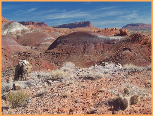
|
|
advertisement |
|
|
advertisement |