| |
|
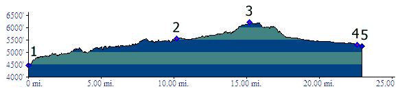
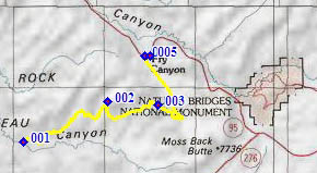
1.(4480ft,mile00) START-END WEST: jct CR259 Red Canyon Road - CR258 Radium King Road
2.(5560ft,mile11) road improves into a mine access road
4.(6210ft,mile16) TOP
4.(5310ft,mile23) START-END EASTl Frye, jct CR258 Radium King Road - Ut95. Profile turns right
5.(5240ft,mile23) START-END EAST ALT: Ut95 crosses Frye Canyon