| |
| |
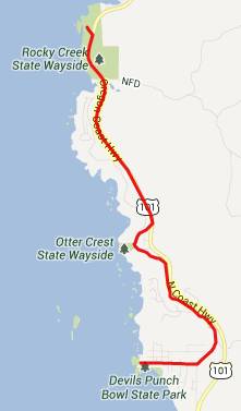
US101 Cape Foulweather
s(u)
 There
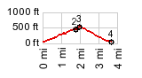
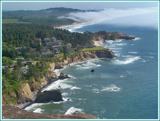
are quite a few points on the Oregon Coastal
bike route that reach over 500ft (the minimum
cutoff point, for me to include a page), but
not so many, that are close enough to the
ocean to afford a good view. This is one of
them. There
are quite a few points on the Oregon Coastal
bike route that reach over 500ft (the minimum
cutoff point, for me to include a page), but
not so many, that are close enough to the
ocean to afford a good view. This is one of
them.In order to get the minimum 500ft elevation gain the elevation profile follows a portion of US101. But following Otter Crest Loop all the way is a better bike ride.
Approaches From North. In order to
give it the minimum 500ft elevation gain, I have
to start the profile on a side road turnoff at
Otter Rock.The highest point is the US101
turnoff to the Cape Foulweather viewpoint From South. (described
downwards). After a scenic respite it's
back to fighting the mega volume of traffic on
US101. Next interesting spot along the road is
Siletz Bay, where an extraordinary volume of
dead wood ornaments the Siletz River. A Dayride with this point
as intermediate summit is on page: FR17
Cougar Mountain s(u)  -
|
|
|
advertisement |
|
|
advertisement |