| |
|
|
|
-
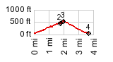
1.(30ft,mile00.0)START-END SOUTH: Devil's Punch Bowl State Park, Otter Creek
2.(440ft,mile01.9) Cape Foulweather viewpoint
3.(mile01.9,560ft)TOP: northern Cape Foulweather turnoff on US101
4.(30ft,03.7mile)START-END NORTH: low point on beach turnoff from US101
|
|
-