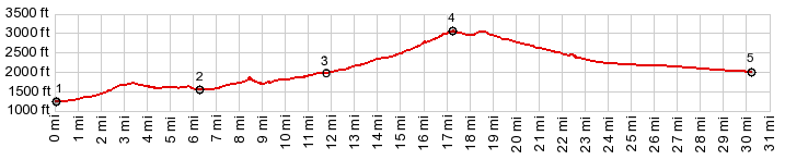
Not a big climb - but a great bike
ride in late October or later, all on pavement
and without rumble strips, through another
variation of south western rock scenery. And yes
- it does meet the requirements for a climb for
these pages. It even climbs quite a bit more
than the 500ft minimum on each side, and it does
it very gently.
Soon after leaving town the road climbs a mesa
with a panoramic view that has no equal, and we
are not in any kind of federal or state land
institution yet, where you have to pay to get in
and park among tour buses. The view is dominated
by the two major landmarks, that have been part of
my rides during the last week, the Beaver Dam
Mountains and the Mormon Mountains. At the next junction the profile goes right into
the Valley of Fire State Park. The road climbs
ever so gently, but with every foot of climbing
the viewing distance seems to increase by at least
a mile. The road crosses through a small gap and
then continues ascending ever so gently betweeen a
multitude of rock formations. Some of the most
contorted and fanciful are on the out-and-back to
detour to Silica Dome and White Domes. Surprise, even after leaving the state park the
road still keeps on climbing. Before reaching the
top, the grade actually gets something resembling
reasonably steep, as a single switchback tops out
on a slightly slanted mesa.
From West. Just let it
roll, or even pedal with all your might, the
comples of ranges in the distance does not seem to
come any closer. One last stop next to the road
shows off the last 8 miles to I15 as straight as a
ruler, and none of it is interrupted by even the
shadow of a cloud.
Dayride with this point as highest summit: ( < The Summit | Lake Mead North Shore Rd s(u) > ) COMPLETELY PAVED: Valley of Fire Hwy s(u) , additional out and back : a short distance north of Logandale near Nv169 > Nv169 south with residential street substitutions > Overton > Valley of Fire Hwy west <> out and back on White Dome Road with turnaround point at Silica Dome >> Valley of Fire Hwy s(u) > I15 east > back on Nv169 south to starting point north of Logandale: 71.5miles with 3620ft of climbing in 5:42hrs (garmin etrex30 m3:19.10.28) |