This is a rough broad dirt road,
starting from a solitary I15 exit in the Las
Vegas vicinity, leading into a dry treeless
mountain complex, named the Mormon Mountains.
Joshua Trees give the area a special appearance.
With ever so slight turns the road traverses a
dense Joshua Tree forest. When the road crosses a
power line, it becomes evident that a road also
follows under these masts. This may make for an
alternate, smoother approach on the lower section.
The main access to the Mormon Mountain wilderness
on this side is via Hackberry Rd, which
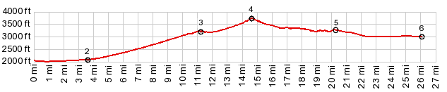
meets up with the profile well below the summit in
the middle of the cactus splendor. At the summit of The Summit, there are no obvious
hiking routes following the ridge line in either
direction. To the west the more interesting higher
summits are quite a distance away. And on the east
side, it looks like cliffs would soon be
encountered by the hiker.
From North. (described
downwards). The first impression from the top is
much bleaker than on the other side, partially
because of the almost complete absence of Joshua
Trees on this side. However descending a ways, the
Mormon Mountains to the west show another
interesting, rough assemblage of cliff surfaces,
and to the east, the view opens up all the way to
the Beaver Dam Mountains in Utah, through a gap
breached by an ever so temporary wash. There is
another access road into the wilderness, signed as
the Horse Spring Rd. Signs next to the road refer
to the road in the profile as Rainbow Pass Rd. but
the only name found on my maps is the curious
designation "The Summit".
Dayride with this point as highest summit: PARTIALLY PAVED / UNPAVED ( < Bulldog Pass | Valley of Fire s(u) > ) The Summit x2: I15 exit 100 <> The Summit << turnaround point a little past jct with Horse Spring Rd. On the way back extra partial out and back on Hackberry Spring Rd: 44.1miles with 2990ft of climbing in 5:16hrs (garmin etrex30 m3:19.10.26). |