| |
| |
Pinto Summit
 When bicycling on US50
across Nevada, two little towns take on greater
importance, than little towns usually do, Austin
and Eureka. The reason is not only curiosity about
what it is like to live in such relative
isolation. it's also practical, you have to eat
and get water. In my experience Eureka was more
practical than Austin, ie you could still afford
to buy some basic groceries here. Pinto Summit is
immediately east of this important little town. When bicycling on US50
across Nevada, two little towns take on greater
importance, than little towns usually do, Austin
and Eureka. The reason is not only curiosity about
what it is like to live in such relative
isolation. it's also practical, you have to eat
and get water. In my experience Eureka was more
practical than Austin, ie you could still afford
to buy some basic groceries here. Pinto Summit is
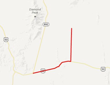
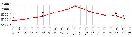
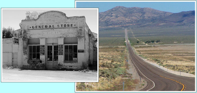
immediately east of this important little town.Approaches From West. US50 reaches a low point, west of Eureka and east of jct Ut278 - US50. A tiny initial climb reaches Eureka. The town boasts two gas stations, one grocery store which also likes to advertise itself as a wild life museum due to a multitude of stuffed animal heads protruding over the twinkies. The town even has a Chinese restaurant (but if it was closed when I was there). But the biggest most elaborate building in town by far is the fire station. It even makes the old hotel and court building look small. The climb itself to the top is not much in the scenic department, in my opinion, tree speckled hills quickly leading the top. From here you can barely make out the next ranges to the east and west, but it is not a good view.
left: there is another store in
Eureka to buy food, besides this one. This one is
closed From East. (described downwards) The more
interesting stretch of road, in my opinion, comes
after you descend this side. It comes when you
emerge from the gap between the Fish Creek Range
and the Diamond Mountains, and let the eye wander
along the latter, seemingly to infinity somewhere
up north. After the view appears the road keeps
rolling down an alluvial fan, loosing several
hundred more feet in altitude. Then it starts
climbing again up appropriately named Pancake
Summit. A Dayride with this point as
intermediate summit is on page: Little
Antelope Summit
|
|
|
advertisement |
|
|
advertisement |