| |
| |
Wheeler Peak Scenic Dr(ow)
I underestimate the number of climbs
I underestimate. So here is another one in that
category. One way to rationalize the
misunderestimation (just to keep an old Bushism
alive) of this particular summit, goes something
like this. ... Before this, I had been traveling
through nearby parts of Nevada south of here, and
really enjoyed those big "2000ft" climbs. So this
one reaches just a little bit higher. But even at
equal elevations, this range is much colder than
those other ranges I had hiked and biked. Mt
Wheeler itself is said to have a real glacier,
though it may just be an icefield that stays
around the entire year (ie no ice, deforming under
its own weight,which is the real definition of a
glacier). In any case, this is Nevada's
premier one way road climb. During a day in
November I saw about a dozen or so cars along the
entire route, and the views reached further than I
imagined views could reach.
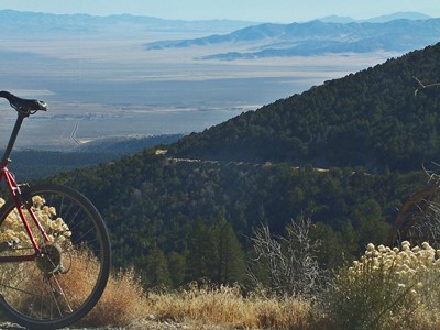
There are no fee booths at the entrance of this
National Park. Just climbing the alluvial fan out
of Baker, before entering the national park, gains
about 1000ft in elevation. Going down this section
the visual clues sent to the brain are, that you
are riding along on a regular plain. It is easy
and freaky to make believe the bike is being
pulled to accelerate by some not understood force
in the universe, like the force that is causing
the accelerating expansion of the universe.
There is only one view point of Mt Wheeler
itself, and during all of the day, except the
early morning, the light is from the front, making
it appear completely flat. There is one other
unpaved road to a viewpoint that I did not take. The summit is in the trees and without views. A
foot trail to Mt Wheeler leaves from here. The
road continues in dense forest and drops about
300ft to another campground and trailhead. Since
that is less than 500ft I am counting this as a
one way summit.
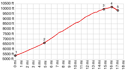
Dayride with this point as highest one-way summit and without two-way summits: ( < Patterson Pass | Skull Rock Pass > ) Wheeler Peak Scenic Dr(ow) : Baker Archeological Area > Nv487 west > Baker > up Nv488 > Mt Wheeler Scenic Dr(ow) << turaround at end of road, lowest point in campground area > Baker <> out and back on Nv487 towards Garrison with turnaround point after ~2.5miles one way >> back to starting point:44.1miles with 5480ft of climbing in 4:58hrs (garmin etrex30 r4:19.11.11) Notes: broke a spoke after the climb. Otherwise ride would have been longer |
 Back to reality - first we need to
ride to the top. All the points in the landscape
by which to measure one's own progress are quite
far away. So the visual clues are limited. On the
lower section there are some great views of 12
thousand foot Mount Moriah to the north. After
that the road actually goes through a sparse
forest. At 9 thousand ft elevation a section of
the road in dark, deep shade has ice on this
November day, even if the rest of the road further
up is much warmer. I was beginning to think there
was something wrong with my hub, when I saw the
tires actually spin on the road. It felt much too
warm for ice on the road.
Back to reality - first we need to
ride to the top. All the points in the landscape
by which to measure one's own progress are quite
far away. So the visual clues are limited. On the
lower section there are some great views of 12
thousand foot Mount Moriah to the north. After
that the road actually goes through a sparse
forest. At 9 thousand ft elevation a section of
the road in dark, deep shade has ice on this
November day, even if the rest of the road further
up is much warmer. I was beginning to think there
was something wrong with my hub, when I saw the
tires actually spin on the road. It felt much too
warm for ice on the road. |
|
advertisement |
|
|
advertisement |