| |
| |
NM244 summit(u): Cloudcraft area 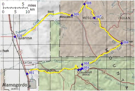 For somebody who
likes to explore the neighborhood on a
bicycle, the desert around Alamogordo has
something in common with coastal California.
But the similarity is pretty abstract.
Cycling on the California coast you can head
in three directions only, but not west,
obviously. The same thing is true for
Alamagordo. But it's not an ocean that puts
the area off limits to bicycle wheels.
Instead it's a giant military reservation,
where the military practices exploding bombs
and other things in the previously pristine
landscape. The first nuclear ( or as
republicans like to call it nucular ) bomb
was also detonated a few dozen miles to the
north, making the area especially
interesting for cancer research. A busy
traffic corridor runs along the boundary to
the military area. For somebody who
likes to explore the neighborhood on a
bicycle, the desert around Alamogordo has
something in common with coastal California.
But the similarity is pretty abstract.
Cycling on the California coast you can head
in three directions only, but not west,
obviously. The same thing is true for
Alamagordo. But it's not an ocean that puts
the area off limits to bicycle wheels.
Instead it's a giant military reservation,
where the military practices exploding bombs
and other things in the previously pristine
landscape. The first nuclear ( or as
republicans like to call it nucular ) bomb
was also detonated a few dozen miles to the
north, making the area especially
interesting for cancer research. A busy
traffic corridor runs along the boundary to
the military area. To the east, like in
coastal California, there are the mountains,
even with a California name, the Sacramento
Range. The most satisfying one day loop in
this area runs over the highest paved road
in these mountains. While riding on top of
the Sacramento Range over this route, there
is no visible clue that you are running
along a mighty ridge above the dessert. The
traverses is in a tiny valley that could be
located much lower, and thousands of miles
to the north, judging from the scenery
From North. The profile starts in
Alamogordo. The route follows the NM 82
shoulder summit to Cloudcraft. The
tourist town has an especially for tourists
constructed boardwalk with Texas Barbeque and
other y'all-wellcome-businesses. The shoulder
summit crests and NM244 turns off to the left
to climb further in a dense needle forest on a
pleasant "damn-crooked" (as one Clouldcrafter
described it to me ) road. The road crests at
a series of forest campgrounds. From South. (described downward): The
next expanded downhill lends itself to trying
out just how fast one can pedal downhill,
gentle grade, few turns, pleasant shallow
forest valley. But there is another gentle
climb ahead inside the Mescalero reservation
up Elk Canyon. The second, lower summit's most
remarkable feature is a downhill sign in close
proximity on both sides, which is not very
remarkable. The road terminates on busy US70
to Apache Summit. Turning downhill the gentle
busy four lane highway is signed as a bicycle
route. It has a lane wide shoulder separated
from traffic by a rumble strip, and while
traversing the Apache reservation it has more
glass on it than a discount liquor super
market has in it, only that here it's broken
up in little tiny pieces. Lanes in traffic
contain considerably less glass, and riding on
the road instead of the shoulder is feasible
since traffic tends to be light. Traversing
the town of Mescalero, the most interesting
view along the entire route may well be a
mighty church edifice on the reservation
(picture included). Continuing down Tulurosa
Canyon is again a pedal-as-fast-as-you-can
downhill affair. Canyon is a misnomer, even
valley doesn't really describe it. I would
call it a slanted plain.
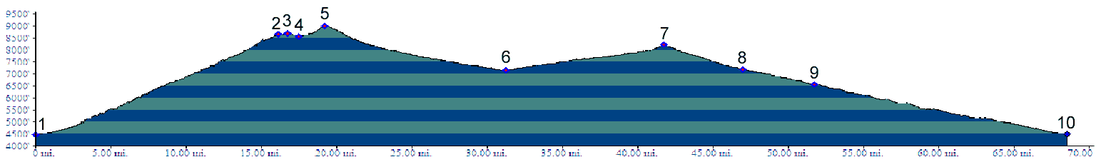
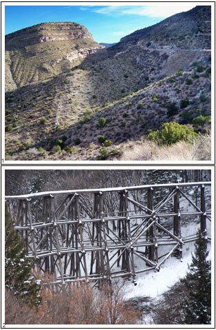
Dayrides. (paved): A loop ride from the south end of Alamagordo to Cloudcraft over the NM244 summit, back through Mescalero and Tulorosa measeured 88 miles with 5600ft of climbing in 6:3 hours, using a VDO MC1.0 cyclecomputer. The loop can be shortened by about 10 miles by starting a short distance north of Alamagordo. (r2:7.11.26)Pictures: Pic 3 taken on the Apache summit side, all others taken on the southern approach and are equally applicable to the US82 shoulder summit: Cloudcroft, and the NM130 shoulder summit: Clouldcroft. 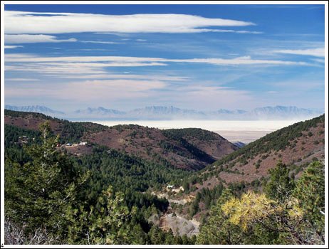
back
to New Mexico's Summits and Passes by
Bicycle |
 Approaches
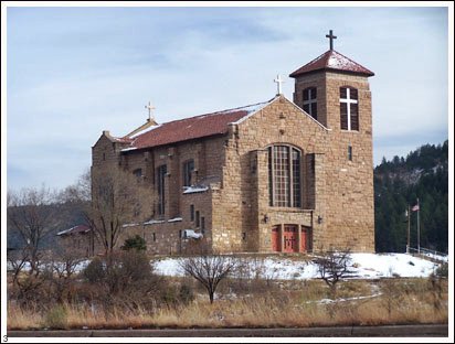 Tours
Tours|
|
advertisement |
|
|
advertisement |