| |
| |
FR150 summit: Santa Fe Ski
Basin
FR150 leads to the top of Santa
Fe Ski Basin without going through it. Combined
with trails in the ski area it can be made into a
loop ride that reaches one of the highest points
around Santa Fe. This can be made into a
substantially longer ride, when combined with a
combination of paved and dirt roads that start
near Santa Fe. This is an 8 shaped ride, that
doubles back on itself. But the distance
duplicated in approach and descent is less than a
mile. For me the major attraction of this ride is
the huge difference in landscapes from dessert
arroyos in the valleys to rounded alpine peaks at
the top.
From South. The ride begins in Santa Fe on
Paseo de Peralta, which is a sort of ring road
around the old colonial core of the city. On its
southern end the turnoffs following NM475 to Hyde
Memorial State Park are well signed. The road
begins to climb steeply through new adobe style
housing developments with entrance gates designed
to impress upon the passersby that the people
behind them have given the developers a
substantial amount of money. Traffic on this
initial stretch is heavier than on the rest of the
road and there is no shoulder. As the road climbs
an early crest, the housing developments recede
further into the dwarf evergreen forest and
traffic thins out. A short drop and the climb
begins in earnest, now in a thick forested canyon
with no hint of where the top might be. Many feet
of altitude higher, the mountain road passes a
picknick area named Aspen Vista. A park bench is
situated strategically to take in the first vista
since climbing above the sea of houses on the
outskirts of Santa Fe. Here FR150 (closed to motorized traffic) starts a
moderately steep climb to a transmission facility
above Santa Fe Ski Basin. The forest opens once to
show the Manzano Mountains as a flat cutout to the
south. Another forested section and finally the
road climbs above tree line, enters the ski area,
and reveals a 360 degree panorama on top. A lake,
a short distance below the ridge line on the west
side is the surprising alpine extreme, visible on
this ride.
From North. (described downward). Rather
than returning down the same way, it is possible
to take a right fork ( when facing downhill ) at
the top onto a service road for the ski area. The
road traverses to the northern end of the ski
area, then switches back and merges into a variety
of trails on the ski runs. The paved parking lot
can be seen from several spots along the way, so
the time required for this this route can be
estimated. If any snow is found on the route it
will be on the north facing runs, even if there
isn't a speck of snow on the summit. This section
involved a lot of walking in my case. But somebody
with more skill and bent on riding every inch of
the way, I am sure would have no problems never
getting off the bike. From the ski lodge the route
follows a lazy descent down the paved road back
past the Aspen Vista picnic area, but then shortly
afterwards turns off onto unpaved FR101 down
Pacheco Canyon. The turnoff is not signed and can
easily be missed. From here it's what seems like
an eternal descent through a forested canyon. The
transmission facility on the top of the mountain
is now a set of marbels on matchsticks, seen
between branches and twigs that divide the sky
into a pattern shaped like broken glass. The first
section of FR101 is rocky, followed by a smoothly
surfaced but deeply furrowed section perfect for a
fast descent, while keeping away four wheeled
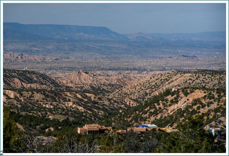
vehicles, followed by more rocks. There is great difference in landscapes on this
ride, but it doesn't happen gradually. It happens
in one abrupt step, when the road suddenly exits
the forest and emerges onto a low ridge above the
badlands of the geological Rio Grande staircase.
Surprisingly the ride continues through
picturesque badlands, partly being turned to more
exclusive housing developments. The final part of
the descent is paved and merges onto the Tesuque
road.
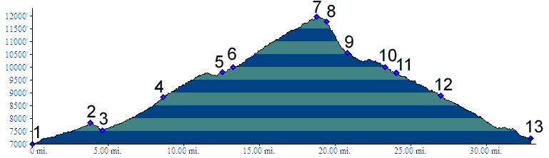
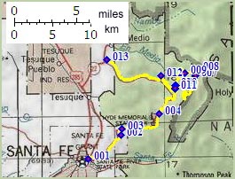
Tours Dayrides. (MTB+paved): An 8 shaped ride beginning at Hyde Memorial State Park on NM475, traversing the southern and northern approaches as described, then continuing to Santa Fe along the mountains, and returning back up NM475 to the state park, measured 50 miles with 6300ft of climbing in 5:4 hours, using a VDO MC1.0 cycle computer (m3:07.11.7). This includes a couple of miles of getting lost in the maze of housing developments between Tesuque Road and Santa Fe, many of which are loops or dead ends, and are useless from a cyclist's point of view.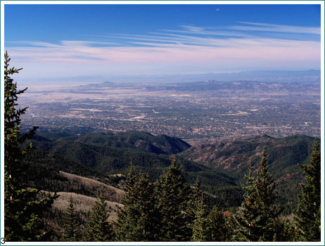
back to
New Mexico's Summits and Passes by Bicycle |
 Approaches
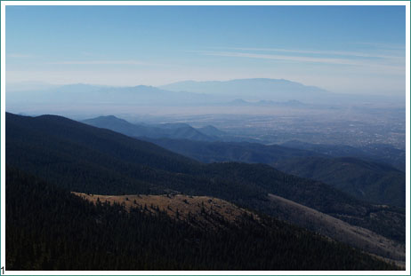
|
|
advertisement |
|
|
advertisement |