| |
|
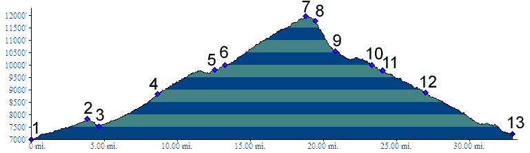
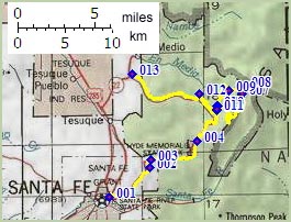
01.(7010ft,mile00) START-END SOUTH: Paseo de Paralta, Santa Fe; route turns right up NM475 shortly afterwards.
02.(7830ft,mile04) intermediate high point
03.(7520ft,mile05) intermediate low point
04.(8810ft,mile09) Hyde Memorial Park camping area
05.(9790ft,mile13) turnoff down Pacheco Canyon is on left; profile continues straught.
06.(10010ft,mile14) FR150 takes off on right; profile goes right
07.(11960ft,mile20) TOP: electronic site avove Santa Fe Ski Basin
08.(11780ft,mile20) end of road; continue on ski area trails; profile to next point is approximate. Less steep routes are possible.
09.10560ft,mile21) pick up NM475 at Santa Fe Ski Basin lodge
10.(100010ft,mile24) same as point 6; Continue straight down NM475
11.(9790ft,mile25) same as point 5; this time go right, down towards Pacheco Canyon
12.(8900ft,mile27) stay left for Pacheco Canyon
13.(7210ft,mile33) START-END NORTH: jct NM592 - rte76, north east of Tesuque