| |
| |
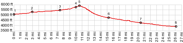
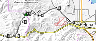
Mullan Pass
The lowest Continental Divide
crossing of the Boulder Mountains west of Helena
is not the modern highway US12 over Mac Donald
Pass, but this dirt road following a historic
railroad route, that is still an important modern
rail connection. This is a quiet gravel
alternative, and a much more pleasant ride
From West. From the point where Mullan
Pass Rd turns off US12 to Mac Donald Pass, both
roads start a definitely noticable climb. The
Mullan Pass Rd follows in close proximity to the
railroad tracks. Both reach an expansive shallow
subalpine meadow, and the two routes part. The
tracks head for a small tunnel, and the road makes
an expansive sweep to the north to reach the
unmarked summit. The road only becomes marginally
steeper than the previous section along the
tracks. The CD trail crosses at the top From East. (described downwards) Shortly
after the summit there is a fine view down into
the Helena valley. As road condtions become a
little more MTB like (sofar it's been a great road
gravel route), the road goes under an adenturous
looking viaduct. I still have quite a few miles
ahead for today. So I decide not to wait for the
train on the bridge for the perfect picture (even
though this line is quite busy). A few more
railroad track crossings and this becomes a
lightning fast decent down a smooth gravel road.
Eventually, at the largest collection of mailboxes
that I have ever seen, the profile joins the
Skelly Gulch Road and makes its way along a set of
complicated turns to the southern edge of Helena 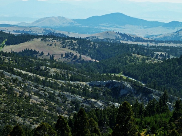 Mac Donald Pass
The Stevens Survey: In 1853 Washington
Territory reached from the Continental Divide to
the Pacific and Isaac Ingalls Stevens wanted to be
its first governor. He got the job through a
number of scheemes and because he was a Franklin
Pierce demorcrat. This loyalty apparently also
qualified him for being in charge of the Northern
Pacific Railway survey, an alternative proposal to
Gunnison's ideas of laying transcontinental rails
over Cochetopa Pass and another proposed route
through New Mexico, favored by sercretary of war,
Jefferson Davis. If Washington Territory was going
to amount to anything it needed a railroad.
Stevens was sure about that. With 240 soldiers,
scientists and engineers, the group was larger
than the other railroad exporatory groups. Stevens sent his underlings in all directions in
an explosion of activity. Stevens first task was
to find a route fit for rails or wagons around the
Great Falls of the Missourri and the 60 miles of
rough country upstream towards Bozeman and Three
Forks. On Sept. 9 lieutnant John Mullan and five
companions left to look for approaches into the
mountains above the Missourri. The pass they found
still carries is still named Mullan Pass. The
young lieutnant could already see emigrant trains
pass through the gap in his mind. He wrote: "Here
therefore exists in the mountains a broad open
pass, through which it is possible that ... a
broad emigrant train will lead from the
Atlantic to the Pacific.
The military road also made cycling history. The time was just after the civil war. The Indian wars were well under way. The army had a cycling enthusiast, a certain leuteniant Moss, stationed in Missoulla. He believed that the bicycle had certain advantages over the horse. He wrote "it does not require much care, it needs no forage, it is noiseless and it raises little dust, and it is impossible to tell the direction of travel from its track". Moss wanted to show the military just how useful the bicycle could be for them. He was granted permission to mount an expedition on bicycle from Missoula to St. Louis, some 1900 miles. During June 1860 Mullan crossed the continental divide on this pass together with his 20 black soldiers on their one speed Spalding safety bicycles. After an arduous trip they arrived in St. Louis in July, requiring 41 days for the trip. I had read this story in Michael Mc Coy's CD guide book. Full of expectation I crested the grassy ridge of this pass. I was expecting to find at least a plaque or histerical marker comemmorating the monumental event. Nothing of the kind. The brave bicycle soldiers have been forgotten, except for some dedicated guide book authors. Instead a sign with a 5 word sentence marks the spot. It mentions some other milityary official who crossed here, without providing further details. I fully intentioned to ride down this pass back into the Helena valley. After all, you haven't ridden over a pass untill you've ridden up it, and just as importantly down the other side. But after I saw the valley below me, baking in the heat like a souflet, while I was still relatively comfortable, I decided to stay in the comfort zone and follow the CD route further North along the ridge. Miles later I crested over another spectacular meadow. It's certainly a pass. But nobody ever bothered to give it a name. A long comfortable decent lead me into the scenic collection of wooden churches, rusty snowmobiles, railroad ruins and lawn furniture, collectively called Marysville. Railroads ( Bozeman Pass > ): As it
turns out, the more southerly route through
Wyoming was chosen as the first transcontinental
railroad. For a time, other roadbuilding projects,
like that of the Lander cutoff (put in place by
the Trump like Lander), also ignored the Mullan
Pass route. But congress approved building the
Mullan Road from the west, starting in Walla
Walla. Mullan soon recognized that the Bitterroot
Range, though west of the Divide, represented a
much larger problem that the Mullan Pass over the
Continental Divide itself. The Mullan Military
Road finally took a more notherly route over Ceur
d'Alene Pass, an on August 2nd Leutinant Mullan
declared victory of his 7 year old dream of the
Mullan Road. It did not last long and it was not
heavily used, and by the time the Northern Pacific
railroad was buit, the Mullan Road was nearly
abandoned. In 1881, the president of the railroad Villard
bought the bankrupt railroad on the open market
Its tracchs reached as far as Billings from the
east, and Pend Oreille Lake, Idaho from the west.
Villard started putting tunnels on the original
route over Mullan Pass and also Bozeman Pass from
the beginning. The Mullan Tunnel was finished in
1883, 3875ft long and reached an apex of 5547ft
elevation. Neither approach required any
exceptional grade. The tunnel on Bozeman Pass
represented greater difficulties, 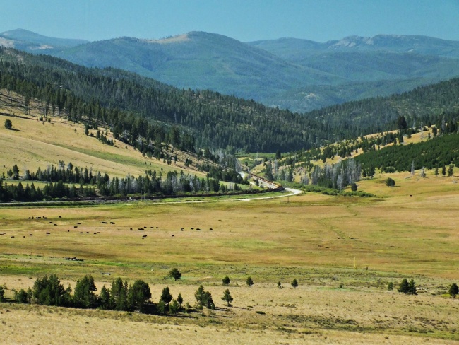 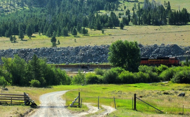
back to Montana's passes and summits by bicycle |
 Approaches
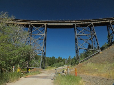 History
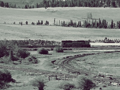 Military Roads.
One year later in 1854 Stevens own role in
exploring for routes had ended. But the people
with Mullan amongst them were nor in the process
of putting much of today's Montana and other areas
on the map: Medicine Lodge Pass, the featureless
Monida Pass, much of the Interstate 90 route
through Washington State (Lookout Pass, St Regis
Pass), the 100 percent flat Deer Lodge Pass. In
March 1854 he brought back a wagon over his own
discovery "Mullan Pass". He saw no point in being
modest: "The mountain itself is nothing more than
a low prarie ridge", even if it does seem a bit
more than that on a bicycle in the middle of an
August heat wave. He descended with "the animals
trotting.
Military Roads.
One year later in 1854 Stevens own role in
exploring for routes had ended. But the people
with Mullan amongst them were nor in the process
of putting much of today's Montana and other areas
on the map: Medicine Lodge Pass, the featureless
Monida Pass, much of the Interstate 90 route
through Washington State (Lookout Pass, St Regis
Pass), the 100 percent flat Deer Lodge Pass. In
March 1854 he brought back a wagon over his own
discovery "Mullan Pass". He saw no point in being
modest: "The mountain itself is nothing more than
a low prarie ridge", even if it does seem a bit
more than that on a bicycle in the middle of an
August heat wave. He descended with "the animals
trotting.|
|
advertisement |
|
|
advertisement |