| |
| |
FR606 French Creek - Thief
Creek Rd summit(u)
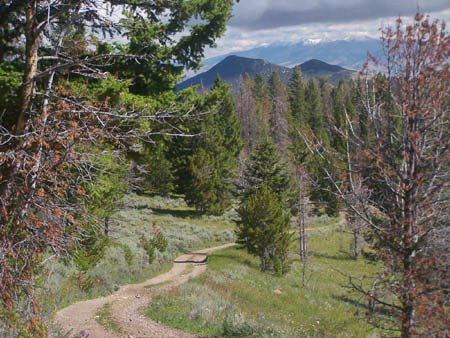
This summit is a high traverse
through the eastern foothills of the Pioneer
Range. It is the highest summit with two separate
approaches in the Pioneer Range that I can find.
Despite the relatively high altitude it does not
cross a major ridge line but stays almost entirely
in forested hills, with some far views.
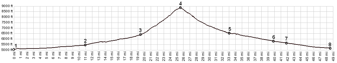
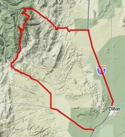
From East. In a car I15 north from
Dillon seems as flat as bowling alley, barreling
up along the mighty Pioneer Range. Cycling on the
spacious shoulder to the right of the rumble
strip, it feels like you are climbing. A exit
named Apex verifies this feeling. The route turns
left up the biggest drainage fan of the Pioneer
Range onto FR801. The highest peaks of the
Pioneers are truncated by lower sagebrush hills
and look especially precipitous from this angle.
FR801 enters the hills and early morning light
makes Tent Mtn, Torrey Mtn and Barb Mtn stand out
in 3d plastic light that makes the peaks seem
touchable. The road passes relics of a mining town
from the Montana gold rush. FR606 diverts left at
the next fork and turns away from the large peaks
on the horizon. Instead it climbs more steepy
through heavy timber on a less traveled road past
a "hanging tree" from the gold rush period, and
labeled as such for the enjoyment of today's
tourist. First contouring along the hill back in
an easterly direction, then heading south it seems
to climb a summit, as one of the high peaks
appears as background behind the cyclist. But this
is just the first of three virtual summits, the
third one being the only one that's not just
virtual, but also real. Stretches towards the
second virtual top are heavily graveled and more
easily walked. On the last traverse the view of
the valley to the east opens up and distant ranges
to the north east had snow on them on August 21st.
On the real top the road crosses a cattle barrier
into a large alpine meadow and presents a sweeping
view of the Big Hole Valley/Pass/Divide area. A
short trail to the right leads to a better, but
still partially obscured view of high peaks in the
Pioneer Range. From West. (described downwards). The
road makes a long, fast, straight traverse to the
north west and with that, it is on a valley floor.
The route continues straight, fast and uniformly
sloped. You can practically count the turns on one
hand, even if you have fingers missing. The only
turn of note is at the junction with Black Mtn
Road. Soon the settlement of Argenta is reached,
and now the rider barrels along on a straight,
hard medalled road all the way to Mt278, just
short of Dillon. I had very strong wind from the
back, which may have clouded my judgment on this
descent. Dayride |
 Approaches