| |
| |
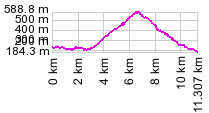
Vrsno summit(u)
This is not a big pass but a very
pleasant afternoon ride between the friendly towns
of Kobarid and Tolmin in Slovenia. It parallels
the main road in the valley below, leading through
closely spaced small villages along the way and
carries little traffic - best of all, virtually no
motor cycle caravan traffic, just a few local
mopeds. A steep out and back climb can be added
from the highest point, leading to a trailhead
town above treeline below the peak Krn.
From West. You head out of town on
the main road towards Tolmin. Go left crossing the
bridge towards Dreznica, but then turn right after
the bridge. This pleasant road goes to the town of
Smast. Staying left for Krn and Vrsno starts a
steep climb towards an ideally located church in
Libusnje overlooking the valley. It makes a great
quiet lunch stop if you got a late morning start.
Leaving Libusnje the switchbacks start continuing
to Vrsno. Here an out and back climb to the town
Krn at 887m is a scenic extension. From East. (described downwards). Right
before the town of Vrsno, a sign points to a right
fork on an initially very narrow road back down to
Tolmin. The initial steep sections give way to
deeply forested parts with intermediate views of
the mountains. The profile reaches a low point as
it approaches route102, but continuing to traverse
slightly above the valley through Slisce to Tolmin
is the logical destination for a half day loop. pictures: 3: between Kobarid and Ladra, 2: church just below the paved one way climb to village of Krn, 3: telephoto shot taken from church in 2. Dayride with this point as
highest summit
COMPLETELY PAVED: Vrsno s(u): Kobarid area > Vrsno s(u) <> turnaround point Tolmin > valley route back to Kobarid: 37 miles with 2500ft of climbing in 3:3 hours (VDO MC1.0 m3:9.6.14).. Notes: includes about 7 miles of sightseeing detours in Tolmin and other places along the way The next day on this Extended Tour, starting at the same point, Kobarid area, is on page: Vrsic Pass
|
|||||||||||||||||||||||||||||||||||||||||||
|
|
advertisement |
|
|
advertisement |
