| |
| |
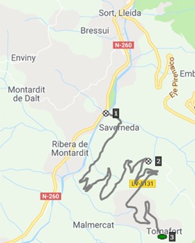
Songuera(sh) /
Tornafort(ow)
This is the lower part of Puerto de Canto from
Sort combined with a small, narrow cari "rural" (a
small narrow road) with an imperfect surface but
outstanding scenery, and a one way climb to an
unforgettable hill town. In order to minimize any
possible surface problems with a skinny tire bike,
it would be best to climb the south side, and
descend the north on the Canto road to Sort.
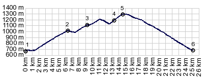
The road works itself in swtichbacks up the hill.
The high peaks to the north are rarely glimpsed.
Then at the only junction along the way, the
profile for the two way summit stays left,
contouring along the slope, taking in every fold
the mountain has to offer. The first collection of
stone huts is Puigfornu, a small high point. Old
medieval structures intermingle with modern beef
farming. The narrow road with the many holes
continues to contour, but the views get much
better the further west you go, because now
Tornafort it moving into ever improving light and
position, in front of peaks behind it. An
additonal village on the other side of the Canto
road also gets noticed. From the lip of houses
named Songuera all the features of the landscape,
with its cliffs and hanging houses, its green
lushness and white lofty hights are in orderely
bowl in front of the viewer. From here the road
climbs in a few switchbacks to meet with the road
between Sort and Collado/Puerto de Canto. This is
the highest point
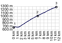
From North. (descirbed
downwards) This downhill is much faster and less
porblematic than the narrow road on the south side
with all its potholes. It also happens to have the
best view points of Sort itself. The road descends
steeply right into to heard of the village and its
green playground arcade.
Sidetrip to Tornafort The most interesting views of this village are from the longer southern approach. The smoothest and most direct way to climb the summit is from the northern approach. On a mountain bike this doesn't make any difference. This road makes it so difficult for regular vehicles to climb that there are few if any tourists on it. I saw one 4 wheel drive car twice, once on the way up, once on the way down. There are several trails leaving from Tornafort, one to a mirador about 1 hrs above, another to Puigfornu on the southern approach
 A Dayride with this point as
shoulder summit is on page: Collado de Canto A Dayride with this point as
shoulder summit is on page: Collado de Canto |
|
|
advertisement |
|
|
advertisement |