| |
| |
Col de Solude
This pass makes a
good daytrip or half day trip from Bourg d'Oisans.
While on the other side of the valley cyclists by
the hundreds are climbing up Alp d'Huez, over on
this side of the valley there are so few, they
still greet one another when they pass. There are
two very special things about Col de Solud. First:
the lower eastern approach is hewn out of the
cliff and has 4 dark tunnels. Second: Several km
over the top are not paved.
Chances are this is not going to be the first bike ride one does, when exploring around the Bourg d'Oisans area. But chances are also good, that during that first or second bike ride you have seen a straight line cut along the cliff south east of the village. That's the lower part of the road to this pass. picture page
From East. Down in the valley, signs do not name this pass by name. But signs on the Briancon side of town do have signs for Villard Notre Damme, and that's the road to this pass. As soon as the narrow road starts approaching the cliff, a sign warns cyclists of 4 dark tunnels. Counting another short tunnel, preceeding the four, actually there are 5. The second one is the longest, and really does require a light of some sort, because in the middle you cannot see either entrance, and therefore it is completely dark. The other 3 are easier. The road connecting these tunnels is just as hair
raising up close, as you would expect from seeing
it at a distance. This is as close to real
exposure on a bike as you can come. Only a low
stone embankment separates the road from the drop
off. It makes a great foreground in photos that
celebrate the grandeur of nature.
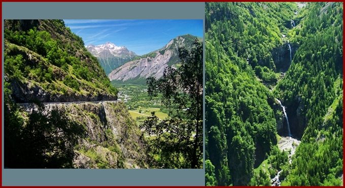
The pavement on the road ends at this group of
fortified looking medieval houses, and a small
sign names the upcoming pass by name for the first
time. The road remains smooth with a surface of
small packed stones. It continues to work up the
shoulder of le Grand Renaud. The view of the
valley and Bourg d'Oisans is never far away.
Basically the road is heading back to the west
now. As the valley comes into sight in full view,
the road descends a short distance, and now
becomes a true dirt road, though still very
smooth. There are actually two crossings over to
Villard Raymond. The one on the right is closed to
public traffic. Past the junction, the other
option makes one more small switchback to the west
and crests quickly and unexpectedly. From West. (described downwards). Narrow
pavement starts up again also. Quickly the road
traverses along below the houses of Villard
Raymond. These are much more spread out over the
hillside than the houses of Villard Notre Dame.
This is the biggest group of settlements next to
the road sofar. The big triangular peak above, le
Grand Renaud (2776m) seems to increase in size
drastically, as the road quickly descends into
forested hillside. Finally the road crosses a
narrow bridge and emerges in Ornon on the col d'Ornon road.
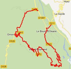
Dayride with this point as
highest summit: Col de Solude , D211B
Villard Reculas s(u): Bourg
d'Oisans > Allemond > D211B Villard Reculas
s(u) > Huez > Bourg d'Oisans > Villard
Notre Dame > D210 > Col de Solude >
Villard Raymond > Ornon > sp: 50.1miles with
6780ft of climbing in 5:17hrs (M4:12.6.14).
The last summit ride
with different start and end points on this Extended Tour
is on the page: Col de
Morte
|
 Approaches
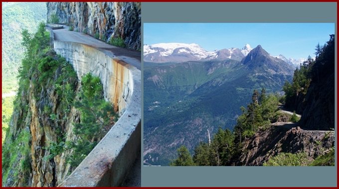
|
|
advertisement |
|
|
advertisement |