| |
| |
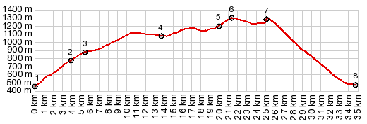
SS349 Lavarone via Sp313(sh) Val Sugana is very
characteristic of the dolomite canyons in
this area. It has close to vertical walls
in many places, and the lake from where
this profile starts, is one of the
vacation hot spots in the valley. This
shoulder summit combines two of the roads
climbing away from the lake. The top is a
forested plateau. So the scenic point of this
loop is not the summit, but the lower
approaches. The summit is a point on the
way to Passo
de Veccena. So that also could be
one of the summit point, if you construct
a much longer loop, using one of these
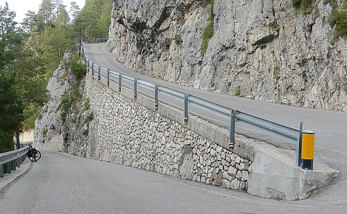
approaches. Especially the right side of
the profile over Sp313 is a remarkable
road. The first picture in the slide show
is from the left hand side of the profile
(eastern approach). All others are from
Sp313.
Continuing on a wider road,
the route climbs above the church of Centa
San Nicolo. Shortly after that is an out and
back turnoff to Rifugio Paludei. In the
nearby village I managed to get some nice
photos of distant dolomite walls.Then the
road climbs onto the rolling plateau. It
rolls so heavily that the road uses an
almost 1km long tunnel to go through one of
the peaks sitting on top. It is well lit but
traffic noise seems amplified somehow. In Lavarone the plateau
transition is complete. Several roads from
below and above join at a grand junction. I
choose one to hop from one minutare vacation
village to the next. Each one seems to have
a small park, pefect for a picnic, a town
square, a closed tabacceria, and a few
albergos to choose from -during a season
when they are open. They are pleasant
scenery when they are closed. A few selected
ones have a scenic lake with an oversized
industrial strength hotel towering at its
end. From the next junction the road climbs
further in switchbacks in calming forest to
reach the summit.
From
East. (described downwards) The
turnoff onto Sp313 directly to Levico Terme
came as a surprise to me. Looking again
closely at my map, the road is shown on it,
though barely visible and not labeled with a
number. It is paved all the way down. It
engages in extreme and narrow switchbacks,
enters two short tunnels 2.50m x 2.50m, that
are not visible until you are practically in
them (there is a sharp turn before the
entrance), and has magnificent vistas up Val
Sugano and the lake below. At least twice I
encountered deteriorating mysterious rock
inscriptions, dedicated to pre WW1 military
heros (?) with stern germanic names.
|
|
|
advertisement |
|
|
advertisement |