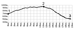
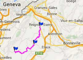
Plateau des Bornes s(u)

When you ride on the long ridge line of Mont Saleve (its highest paved point on the south part of the ridge is Col des Pitons) and look east to the mighty snowcapped wall of the alps, you barely notice that the land immediately below is not really flat, but actually contains fairly large hills. For the largest part these belong to the Plateau des Bornes. At least one signed bike route runs through it. Its charm lies in small peaceful lanes, that travel along cultivated fields, and all varieties of hidden away, private homes. At the very top waits a perfectly situated chapel. If you look for it you can also find some good mountain views along the way. The pictures below were taken from a clearing, during a two minute walk in field away from the road.

1.(700m,00.0km) START-END WEST: D27 bridge over Les Usses
2.(920m,10.9km)TOP: point of highest elevation, just after La Chapelle De Rambaud
3.(500m,19.3km)START-END EAST: D2 before entering Reigner-Esery

Approaches

From West.
The profile starts where D27 crosses a peaceful water named Les Usses, which runs along the length of Mont Saleve. The road climbs in small turns, between fields and houses, as if never being able to make up its mind about where it wants to go next. For a cycling road, this apparent indecision is a good thing. If the ride is too short, this can be remedied by adding more of the same. Just take some of the countless small detours which all eventually return to this road.

Along the path of the profiled route the road numbers change, but the bike signs reading "Plateau des Bornes - Sud" are consistent and reliable. They eventually wander away from the road altogether and lead down small Chemins between fields and occasional houses. It is in this section, where I found the meadows with the views in the photos. The gentle path leads downhill a little and then climbs again, to reach its highest point just past la Chapelle. This church is located approximately on the highest point of the plateau. On the map the access roads put the summit at a slightly different location, away from the chapel.

From East. (described downwards) Following the profile the peace ends here. The downhill funnels the road into increasingly heavier traffic direction la Roche s Foron. Downhill this is not a problem, but approaching from this side it may be wise to search for a detour. My path headed direction Annemasse.

A Dayride with this point as intermediate summit is on page: Col des Pitons


advertisement

advertisement