| |
| |
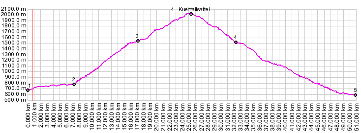
Kuehtaisattel The Kuehtaisattel is a large
climb close to Innsbruck. It starts in the
lowest valley around, the Inntal, and reaches
above 2000 meters. Its parallel course to the
Inn valley means relatively little truck or non
tourist traffic. But the top is a heavily
commercialized area with ski lifts and hotels,
and also water power generation facilities from
two reservoirs. All these things are also a
cause for traffic. Many cyclists use this road
on weekends. Motorcycle traffic is present, but
its not quite the overwhelming mass as the more
touristy passes.
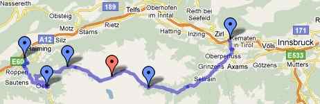
Approaches From West. Starting at the river
Inn and its magnificent bike path
(Innradwanderweg), you make your way to the town
of Oetz. Despite of where some maps show the
turnoff to Kuhtaisattel, it is south (upvalley) of
the town at a rondell. (My Falk Altas shows the
turnoff on the north side). The road engages in
several switchbacks and rises to great viewing
point of the Oetz and Inn valleys. During my
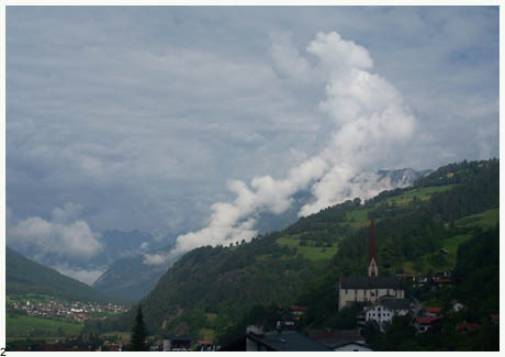
summer ride over this road, the clouds building
over these valleys were the most memorable view
along the entire route. Then the road turns to
follow a mountain stream (Stockacher Bach) in the
forest and the views are lost. This climb
continuous fairly steeply for quite a while to a
ski town. Exiting it, the road grade increases to
18 percent. Finally the treeline comes into sight,
as well as a damn of some sort. This turns out to
be a water reservoir. Its grassy shores are shared
by free roaming cows, wandering tourists, power
lines, parking lots and power generation
equipment. Its one more short climb to the summit,
where a whole other village of multi star
businesses lie in wait to do business. Ski lifts
abound, and looking up you can see a mighty second
damn, collecting more mountain water.
From East. (described downwards) The
weather must be harsher on this side. The trees
start at a substantially lower altitude. The road
goes straight down the bottom of this stark
valley. There are hardly any curves and its not
too steep to just let the bike roll on its own.
The road traverses two long open gallery style
tunnels. At the town of Sankt Sigmund in the
Sellraintal the ski lifts already seem a world
away. This seems like more like a hiking paradise,
gathered around a picturesque church. Even more
promising are the views from the next town,
Marendabach, up the Luesenertal, at the end of
which a triangular horn waits for climbers. The
road down the Kuehtaisattel continues to
descend, now through a narrow valley with another
short gallery tunnel, soom emerging in Kermaten,
near Zirl. You can pick up the bike path
(Innradwanderweg) again near the river. It is
paved, except for a few, very short sections. 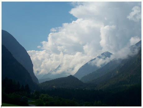
Tours Dayrides. A loop ride
with a few additional kms to approach was: Roppen
(near Oetz) - Oetz - Kuehtaisattel - Kermaten -
Zirl - returning to the starting point on the bike
path (Innradwanderweg) measured 62 miles with
5300ft of climbing in 5:4 hours. (m3:9.7.5).
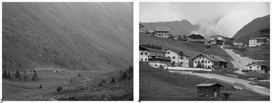 pictures: pics 1 and 2 show the morning view up
and down the Oetz valley, promising afternoon
storms; taken during the initial climb on the
western side. Pic 3 just east of the summit. pic 4
shows the overdeveloped summit.
|
||||||||||||||||||||||||||||||||||||||||||
|
|
advertisement |
|
|
advertisement |