This summit is a little lower than
the one with all the tourists on the top, Comares s(u).
But from the top of Comares, after being dazzled
by the cloud display around El Torcal, I notice
one of the less conspicuous views. It is a
church below, sitting on its own private
hilltop, ringed by a maze of white houses. That
is the town Cutar and this pass allows a much
close look.
The road is signed as going to Cutar and it
traces along the hillside in regular meanders,
that a snake could make to propel itself forward.
All of a sudden Cutar appears in picture perfect
foreshortened form, one building stacked on top of
one another, like a symbolic map. This map would
be utter chaos if it were not for the two anchors,
the church on the top, and something that looks
like an arcade in the cemetery area. The yelling
of children eminates from below and there are no
signs of tourist businesses. This is the most
authentic trip back into time along my route
today. The relatively narrow empty road reaches a
well defined pass soon after that. Here a
concrete/unpaved track connect to the area near
the top of Puerto de Santopilar.
From South. (describe
downwards) The Mediterranean is visible between a
series of algarve cactuses next to the road and
behind several bare roof top shaped, burned green
ridges. White home are sprikled on the ridges in a
regular pattern, almost like patches of snow in
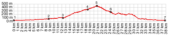
the spring. In Almachar my route turns up into the hills one
last time. But I continued the profile down into
Benamocarra and Velez Malaga to show the maximum
elevation gain.
|
|
|
advertisement |
|
|
advertisement |