| |
| |
Puerto de Cotefablo
... Another pass running
parallel to the main ridge of the Pyrenees. But
this one turns out to be different than the ones
further west. Probably because of the closeness of
a French border crossing, this road has heavier
traffic, and no shoulder. It is still perfectly
manageable, but not nearly as peaceful as the
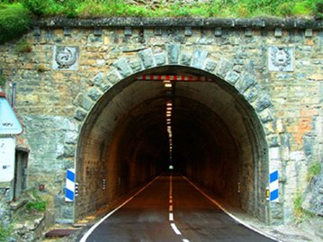
previous passes on this tour. The top is a tunnel
and most of the views are on the west side.
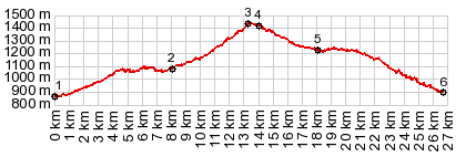
The road climbs quickly along a low forested
slope. Yesero appears as a lip of house surrounded
by wet leaves. It is starting to rain. At one
point the curves in the road lead in a direction,
heading straight for the snowy main ridge of the
Pyrenees. The real mountains make a short
appearance framed by leaves. A scene like this is
in the slide show below, where the foreground is
an unpaved side road. Climbing further and looking ahead at the deep
green cuts in the landscape, it is impossible to
figure out where the pass could be. That is
because it is located at a 683m long tunnel, and
comes up completely unexpectedly.
From West. On this side of the curved
tunnel there are a few picnic tables and a
derelict parking lot, that serves as
trailhead to walk above treeline from here. On
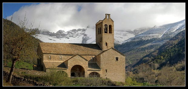
this side also, the road makes a big swerve in
direction mountains. The resulting scenic spot is
accentuated by an old church, the Linas de Broto.
Much of the current building is from the 16th
century. But the first church at this location
goes back to medieval times. It often surprises me
in Spain to find large churches in a great
mountain environment, but hardly a town nearby,
that could fill the church. The current town
"Linas de Broto" has about 59 inhabitants. It
takes some time to find a good spot for a
photograph without power lines. The photographers
of the included pictures have all been very
skillful to avoid them also. The weather on those
pictures is also better than what I experienced.
The descent to Broto leads along forested curves
that are a sort of viewing balcony on the rounded
foothills below and their clusters of towns. Historical Notes The Tunnel was build in 1935, and was almost
dynamited during the Civil, wich came just a
little later
A Day on a Tour with this point as highest summit: ( < Alto de Zuriza s(u) | Buerba/ Vio s(u) > ) Puerto de Cotefablo , Alto de Fanlo s(u) , Buerba/ Vio s(u) : Jaca > N330 west > N260A north > Biescas > Puerto de Cotefablo > Broto > Fanlo s(u) > Buerba/ Vio s(u) > Labuerda > Ainsa with detours around town (r5:16.4.5) Notes: gps data on stolen computer |
|
|
advertisement |
|
|
advertisement |