| |
| |
Puerto de Beret
The most impressive thing to me, about this pas,s is the sweeping tundra plateau on top. Various ski lifts start on this plateau and reach up into the bare landscape of large rounded knobs. One could plan may ski tours or hikes from up here. People who like to go skiing with the help of lifts usually expect a comfortable wide paved road to the bottom of the lift., and they get it in this case too. The other side is partially unpaved and leads down a high, wild and mostly forested valley, sometimes in a traverse. The name Beret applies to the ski area, the plateau, and the mountain pass.
Nine switchbacks lead up the ridge. The ramps leading west give a perfect view of the valley of the Arriu de Ruda and the Puerto de Bonaiqua. The ramps leading east focus the view on the ridge behind Col du Portillon. From a geographic standpoint, Col du Portillon is said to cross the main ridge of the Pyrenees. When you cross it on a bike it hardly makes that impression. But from this vantage point, you could be convinced that this is actually so. But back to ride up to the Porte de Beret. On the
last switchback two snow pallisade tunnels
complete the climb to the tundra plateau.
Everywhere you look is mothballed skiing
infrastructure. You are practically biking across
a ski slope. But few, if any trees had to be cut
down, since this area is completely above treeline
already 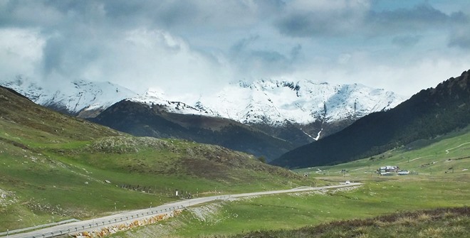
From East. (described
downwards). After a flat section on the plateau,
the pavement ends. For the next part of the
descent, a mountain bike is the appropriate
vehicle. I did it on my touring bike - very slowly
- and still broke a spoke.
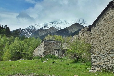
Some time later, the presence of a large stone
building below the ringing cattle signals the
first improvement in surface. A road bike with big
tires from now on is again a perfectly viable
vehicle to travel down this valley. The road
remains at the bottom if an incised V shaped
valley. The paved section is long enough to take
in three more remote villages. This time the
villages are not hilltop towns, instead they sit
defensless on the valley floor. The first one has
a picturesque roman type arched bridge on its
western exit: Alos d'Isil. Then the road cross a
high notch, like a rifle sight, and drops down in
a large sweep to the village Isil itself. The next
village, Esterri d'Arneu, remains next to the
road. If the route leads directly back to
Vielha, you also get a birds eye view of the same
village, because there is another easily missed
climb separating the two pass approaches. This is
not shown in the profile. Instead it includes the
lower approach towards Sort.
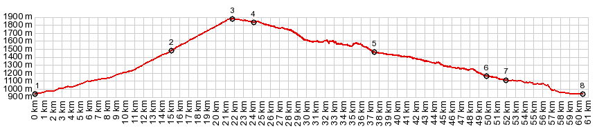
A Dayride with this point as intermediate summit is on page: Port de Bonaiqua |
 The road quickly goes below
treeline, and makes a large sinuous detour to the
north. Peaks in the 2 thousand to 2.5 thousand
meter range appear snow covered and cloud obscured
regularly as background to alpine meadows. A major
intersection of hiking trails and a refugio
happens, as the road gets close to Port de Salau,
relatively speaking. Actually, Port de Salau is
located up high on the ridge to the north, even if
on the map it looks very close.
The road quickly goes below
treeline, and makes a large sinuous detour to the
north. Peaks in the 2 thousand to 2.5 thousand
meter range appear snow covered and cloud obscured
regularly as background to alpine meadows. A major
intersection of hiking trails and a refugio
happens, as the road gets close to Port de Salau,
relatively speaking. Actually, Port de Salau is
located up high on the ridge to the north, even if
on the map it looks very close.|
|
advertisement |
|
|
advertisement |