| |
| |
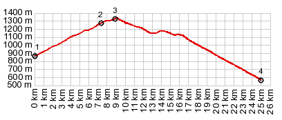
Collado d'Arnat s(u)
This was one ride, where I got two
passes for the price of one. Nothing on my
Michelin Spain atlas hinted at the presence of
Collado d'Arnat. A short section over the top is
unpaved, you could even call it deep gravel. But
it is only about a km or so. Amazingly this seems
to be enough to keep vehicles of all kinds away
from here, in spite of the incredible scenery on
the east side. I only saw 2 cars on no cyclists on
a Saturday in May during the section over the top
(between Somes de la Vansa and N160)
But maps in the scale 1:400 thousand can be
deceiving. A wonderfully smooth road soon after
leaving the couple of houses, that make up
Sorribes, lead me downhill. So far - so good. But
there was one more pass on the program today, that
I had no idea about - this one. Unfortunately it
started raining on this side, so I do not have
many pictures. The road climbs out of a limestone
canyon, its various cliffs melting into one
another in shades of purple, as the last rays of
sun reflect from a very dark cloud. The road heads
for the same gap as a set of powerlines - surely
that is the top. But actually the road keeps on
climbing while the powerlines disappear out of
sight below, then the road becomes unpaved. A
large amphitheater of landscape appears on the
left. I wanted to believe that is the way down,
but actually it is just another vantage point on
the climb behind me. Finally there is a gently
summit point as the road starts to descend into a
new landscape. This happens some distance past the
spot that is marked Collado d'Arnat on the map.
After all that lonely road riding the busy
highway looked scary from above. But actually it
turns out, that it has a good shoulder all along
the way, with lots of signs demanding 1.5meter
clearance to cyclists from motorists. After
joining the main road direction La Seu (this is
not part of the profile). the road immediately
plunges into a 700 meter tunnel. But this too is
no reason for concern, good bike lane, brightly
lit all the way.
A Dayride with this point as intermediate summit is on page: Collado de Trava |
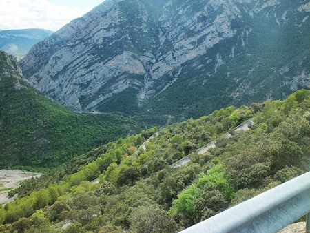 From South. (described
downwards) The village near the top is
named Montan. It is nothing special. It almost
seems like a modern farm. But the canyon
landscape is special. It has a more totured look
on this side - more angles, more obtuse triangels,
fewer equilaterals.The great experience of this
particular ride is still ahead. It happens when
the road approaches the limestone cilff on the
west side of this plateau. First it follows its
edge, as if looking for a way down and not finding
one yet. Instead the cyclist finds new
perspectives on the landscape below. When the road
finally does find a way down it does so with
the help of 18 tight switchbacks into the canyon.
They do not show up on the Michelin atlas. And
that is just one of the reasons why this way to La
Seu d'Urgell is quite a bit longer than it looks
on my particular map.
From South. (described
downwards) The village near the top is
named Montan. It is nothing special. It almost
seems like a modern farm. But the canyon
landscape is special. It has a more totured look
on this side - more angles, more obtuse triangels,
fewer equilaterals.The great experience of this
particular ride is still ahead. It happens when
the road approaches the limestone cilff on the
west side of this plateau. First it follows its
edge, as if looking for a way down and not finding
one yet. Instead the cyclist finds new
perspectives on the landscape below. When the road
finally does find a way down it does so with
the help of 18 tight switchbacks into the canyon.
They do not show up on the Michelin atlas. And
that is just one of the reasons why this way to La
Seu d'Urgell is quite a bit longer than it looks
on my particular map. |
|
advertisement |
|
|
advertisement |