A176 Anso - Garde s(u)
This forested ridge
separates the valleys of the Rio Veral
from the Rio Eskal. It's one of the few
low foothill road summits in this area,
that actually has no views of the high
mountains. The peaceful climb through the
forest is divided into memorable segments
by passing through several old,
interesting villages.
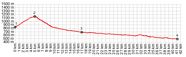 |
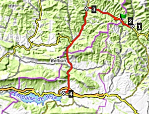
1.START-END WEST:river
crossing in Anso
2.TOP A176 Anso - Garde s(u), 1150m
3.turnoff to Garde
4.START-END EAST:jct A137 - A176,
south of Zuriza
5.START-END EAST ALT:jct A137 -
N240, on the east side of Embalse de
Yesa
|
 Approaches Approaches
From East. The
profile does not include the entire shallow
climb up the valley of the river Veral from
Yergues. It is even shallower than the other
sidef between points. 4 and 5. The dayloop
below also does not use either of these
lower parts. But instead makes a loop over
the higher Alto de Zuriza to the north
After leaving Anso, my
favorite point along this route, the road
stays left, and climbs up a ridge with a
nice vantage point onto the old section of
the village. Within the last 5 years, an
apartment complex has been added to the old
row of houses. Those are the blessings of
the 21st century. The rest of the climb is
in the forest and even the summit has no
discernible far views.
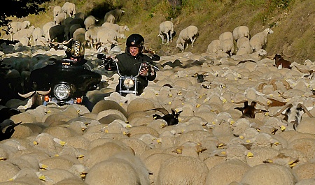
From
West. (described downwards) A fast,
curvy decent lead in my case - right into a
sheep-jam. These roads are famous for their
sheep traffic jams. If it were not for that
jam, I probably would have cruised right
through Garde, and never noticed its old
church and boxed together roof world. Once
on NA173, going downhill, the road is wider
and busier again, and the towns have more
artifacts of the present century.
|
|
|
cLiCk on image ,
arrows , or thumbnails to advance
slideshow
|
A Dayride with this point as intermediate
summit is on page:
alto de Zuriza
|