| |
| |
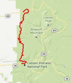
FR17 Lassen National Forest
s(u)
There must be hundreds of roads
like this in the northwestern states, forest roads
that climb in thick forest, with barely a hint of
a far view. So they may look and feel
interchangeable. For some reason this one has a
sign, marking it as a biking route. But this may
just refer to sideroads in the general area. The
surface is medium heavily graveled, and it does
not seem perfect for cycling. But this road makes
the missing link in a loop over the Lassen National Park
Road Summit.
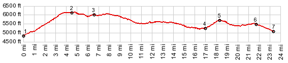
From South. East of Mineral, a
conspicuous sign displaying a bicycle, points out
this dirt road, as being 24 miles long and
connecting to Ca44. The road starts with a
relentless climb in thick growth forest, just
barely giving a hint between the lush vegetation,
that there is a valley below. After about a 1000ft
of climbing the slope levels out, and the road
traverses along a green ridge. The intersection
with 30N16, a shorter connection to the Lassen National Park
Summit is well marked. The road crests at an
indistinguishable spot in the forest From North. (described downwards). After
lots of gentle rolling along, the most exciting
thing is probably passing the sign for the Heart
Lake trailhead. Actually - come to think of it -
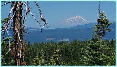
the most exciting thing was a half second long
view of what must be Mount Shasta to the north. If
I would ride this again I am sure that I would
miss this short glimpse. But for all I know there
may be other microsecond long views (when seen
from a moving bicycle).
A Dayride with this summit as
intermediate summit is on page: Lassen National Park
Road Summit
 |
 Approaches
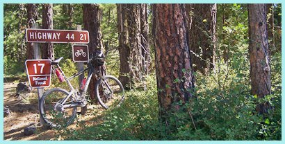 Then gentle distant ridges appear
in the distance, disolving in the haze. The road
passes several clear cut areas, with just a
curtain of trees between them and the road. Before
getting to pavement, there is another small climb
of about 400ft. The jct with Ca44 shows up
completely unecpected.
Then gentle distant ridges appear
in the distance, disolving in the haze. The road
passes several clear cut areas, with just a
curtain of trees between them and the road. Before
getting to pavement, there is another small climb
of about 400ft. The jct with Ca44 shows up
completely unecpected.|
|
advertisement |
|
|
advertisement |