| |
|
|
|
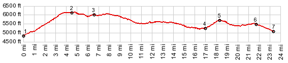
1.(4850ft,mile00.0)START-END
SOUTH: westernmost turnoff onto Viola Mineral Rd, east
of Mineral
2.(6190ft,mile04.6)TOP
3.(6070ft,mile06.7)tunoff on right onto FR29N22 is a
shorter connectionto Lassen NP
4.(5310ft,mile17.0)intermediate low point
5.(5730ft,mile18.4) intermediate high point
6.(5510ft,mile21.8)START-END NORTH: profile turns left
onto Ca44
7.(5120ft,mile23.3)START-END NORTH ALT: jct
Ca44-FR32N17 to north
|
|