| |
| |
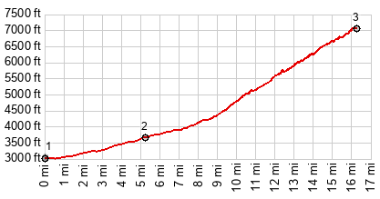
In many ways this is my favorite
one-way climb in Arizona, and in others it's
my least favorite and frustrating. This is a
gravel road, but very smooth and ridable, with
excellent views and everything else that is
good. Unfortunately a large portion of the top
is officially closed to all traffic, except
for observatory business.
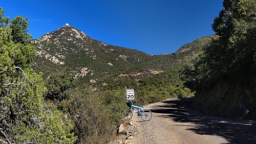
There are quite a few observatory
service vehicles that make the run to the top.
Consequently the road is kept with a very smooth
surface, even partly paved. The first pavement
lasts till the road climbs into scenery,
dominated by the initial hogbacks to Mt Hopkins.
After an unpaved stretch behind the lower
hogbacks, pavement resumes. When the pavement quits again the
climb has entered its second stage. A set of
chained pylons guard the narrow road from the
dropoff. Their shadows leave gemetric patterns
on the smooth dirt, as the sinuous track climbs
higher and higher. Unlike anther more famous
out-and-back climb to Mt Graham, this road tends
to be in the sunshine morning and afternoon,
which makes for pleasant temperatures and great
light for taking pictures, during the short days
of riding season. The spaghetti salad below
reminds me personally of the climb up Grand Mesa
in Colorado via its Land's End gravel road
approach. Finally the road enters a low
evergreen forest for the third and last stage.
|
 This
last stage unfortunately is over before it
really ever begins. Looking above you see the
last section of swtichbacks climbing to some
support buildings and then the observatory is
still higher. It looks enticing and reminds me
of the last set of switchbacks up Mt Evans
(excuse me - Skyblue), even if the environment
here is 100 percent different. But this section
is over before it ever begins. As soon as the
road crosses a saddle that opens the viewshed to
the east, it also ends at a locked geat, with a
complete set of threats what will happen if you
decide to go up anyway. While I had my lunch
there several service vehicles passed through.
They did not seem like cycling afficionados, to
put it mildly. What would be a two directional
highway with turnouts for oncoming traffic in
countries accustomed to mountain roads, is
closed to all traffic here. But what would you
expect from a place where they put rumble strips
on the side of the road in order to make life
more difficult and dangerous for cyclists? The
gates are at 7060ft and the highest point of the
rroad is at 8520ft. From talking to other local
cyclists later ... it may be useful to know that
on Sundays, there is no official observatory
traffic, and that the barricade is easily
bypassed with a trail on the right.
This
last stage unfortunately is over before it
really ever begins. Looking above you see the
last section of swtichbacks climbing to some
support buildings and then the observatory is
still higher. It looks enticing and reminds me
of the last set of switchbacks up Mt Evans
(excuse me - Skyblue), even if the environment
here is 100 percent different. But this section
is over before it ever begins. As soon as the
road crosses a saddle that opens the viewshed to
the east, it also ends at a locked geat, with a
complete set of threats what will happen if you
decide to go up anyway. While I had my lunch
there several service vehicles passed through.
They did not seem like cycling afficionados, to
put it mildly. What would be a two directional
highway with turnouts for oncoming traffic in
countries accustomed to mountain roads, is
closed to all traffic here. But what would you
expect from a place where they put rumble strips
on the side of the road in order to make life
more difficult and dangerous for cyclists? The
gates are at 7060ft and the highest point of the
rroad is at 8520ft. From talking to other local
cyclists later ... it may be useful to know that
on Sundays, there is no official observatory
traffic, and that the barricade is easily
bypassed with a trail on the right.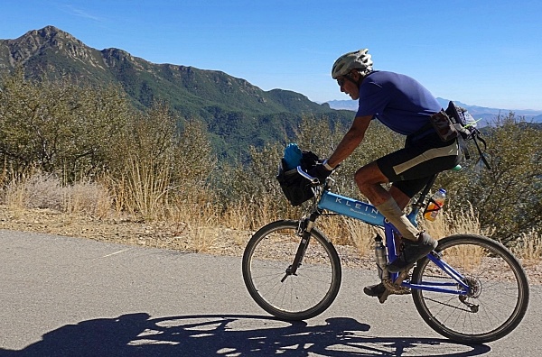
|
|
advertisement |
|
|
advertisement |