| |
| |
Wilson Mesa : Hughes Road(sh)
A ride over Wilson Mesa is sort
of a mixture between a road ride through wild
mountain scenery and an unguided tour through
Beverly Hills. Yes, most of this route is on a
dirt road. But this is not your ordinary type of
dirt road. This is not a dirt road with various
degrees of washboard surface while being passed by
a speeding truck or ATV in a cloud of dust. During
my traversal of this route traffic consisted
almost exclusively of various trucks that are
needed in construction or home improvement tasks,
including the occasional concrete mixer. The
country may be in a housing crisis in 2011, but
the "upper ten thousand" go happily building on.
Actually - rather than calling it a dirt road, it is really more of a hard medalled surface. This road is not paved only because it is fashionable to be not paved. If you happen to be a millionaire and have a multimillion dollar estate at the end of a private road in the mountains of Colorado, it really should be a dirt road, to have the appropriate air of sophisticated isolation about it. Many homes of this type are discreetly hidden in the forested hills around Telluride. However, it you also want a million dollar panoramic view to go along with the million dollar house, you must expose yourself. Of course I mean your house, or more appropriately - mansion. The views from Wilson Mesa couldn't be more magnificent without leaving the planet. I'm sure that's what the developer told his clients too. Two fourteeners, named after the topographer of the Hayden Survey, on the south side (that would be Mount Wilson and Wilson Peak). Actually three fourteeners in total, outline the western skyline, rocks and ice in crisp sunshine, foregrounded by a blaze of yellow aspen during fall. On the other side of the mesa part of the amphitheater of mountains surrounding Telluride make up the horizon.
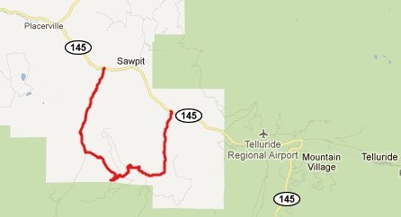
From West. The western most approach to
Wilson Mesa goes up Fall Creek Road, also labeled
57P Road on maps. The first four miles are a rough
hard pavement, the next miles are good dirt road.
The medalled surface starts on top of the mesa.
The next left turn, from 57P Road to Elk Creek
Road, direction Wilson Mesa is also signed. Within
two miles this road offers two turnoffs onto
Wilson Mesa Ranch Road. If you don't take either
one, the road ends at yet another gate to a locked
estate. Naturally the two ends of the Wilson Mesa
road connect. The profile takes the more direct
route, which is the first or lower turnoff. (As a
separate note: A loop ride over the entire Wilson
Mesa Rd, descending back down Fall Creek can also
be seen as a summit. The descent before rejoining
the original approach is greater than 500 feet).
But in order to make this into a more satisfying
loop ride, you have to turn off the Wilson Mesa
Ranch Road. This turnoff is labeled Hughes Road.
It traverses the highest point at its junction
with WE Anderson Road. Turning left here gets you
a few feet higher, so the Hughes Road summit point
is a shoulder summit to what becomes the Whiteley
Road s(u).
From East. (also described upwards).
Riding the mesa from this side eliminates the
difficulty of having to pick your way through the
development to find your way down the other side.
It all falls into place more easily going
downhill. From the beginning - the turnoff from
Co149 is just as inconspicuous, and also just as
clearly signed as the western approach. The sign
reads Silver Pick Basin Road. It is also the
approach road to climbing the Mountains Wilson
(Peak). This road becomes hard medalled almost
immediately after the turnoff. The right onto
Wilson Mesa is also signed. After a short distance
you pass the first attraction on the Rodeo Drive
tour, a parking lot for various horse trailers,
with the accompanying residence. The ranch gate
reads "El Prado". The road loops around to the
right, climbing very steeply in places, and then
reaches the summit to meet the signed intersection
of Hughes Road with WE Anderson Road (whoever his
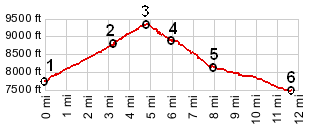
is). Dayride with this point as highest summit: Wilson Mesa: Hughes Rd(sh) , Wilson Mesa Whiteley Rd s(u) : 5 miles up Fall Creek Rd > up Elk Creek Road > upper western access road to Wilson Mesa > up WE Anderson Drive > Whitely Drive Rd s(u) > down lower western access road to Wilson Mesa > down Fall River Road > east on Co149 > up Silver Pick Basin Road <> out and back several miles on this road > up eastern approach to Wilson Mesa > Wilson Mesa: Hughes Road (sh) > down lower western access road to Wilson Mesa > back to starting point: 35.1miles with 4020ft of climbing in 3:42hours (VDO MC1.0, m3:11.9.22).
|
 Approaches
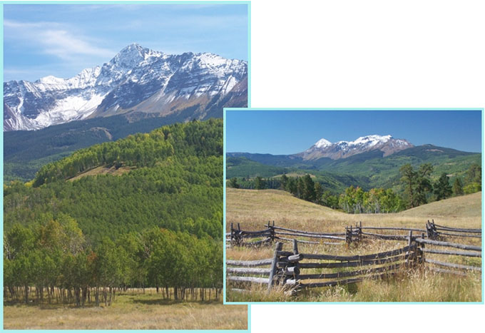
|
|
advertisement |
|
|
advertisement |