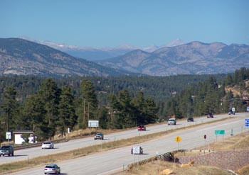
< Left Panel   Colorado Summits and Passes   Areas   Tables   Maps   All Favorites  
Main Panel:   Main Page   Map+Profile   Rides   Colorado Map  


US285 - Co74 shoulder summit: Conifer

Highest Point:
8280ft

Southern Approach:

drop
[1] from Morrison, jct: Co8-Bear Creek Canyon, via Co8 and US285 (5800ft) 2480ft 14+1/2miles ~400ft
[2] from jct US285-Co8, via US285 (6120ft) 2160ft 12+1/2miles ~400ft
Western Approach:


[7] from jct: Co8-Bear Creek Canyon, via Bear Creek Canyon and Evergreen on Co74 (5800ft) 2480ft 19+1/2miles ~100ft
 
The southern approach profiled here goes along US285, since this is the most direct route. US285 is a busy 4 lane road, generally with a wide shoulder. Cycling on it is legal and (on this section) safer than many 2 lane roads, although the shoulders can be sandy in the spring. However substituting the Deer Creek Canyon shoulder summit, and South Turkey Creek Road for the lower southern approach is a better option.