| |
| |
Paradise Divide
The Crested Butte area has some of
the most popular high single track trails in the
US. For people who like pass roads, there is also
this incredible smooth surface high dirt road. It
seems to me this is one of the great Colorado pass
roads, even if it doesn't make it into many books,
like the Colorado Pass Book, or "The Great Gates
?. The reason is probably, that from a "just get
from one point to the other"view, this is just a
more difficult approach to Schofield Pass.
The approach goes over a shoulder summit point on
that route, and then descends less than 300ft down
the wetter northern side. At the jct with FR734,
three equally smooth roads meet. There have been
barely any loose rocks whatsoever on the climb so
far, and it continues that way to the summit and
beyond. It makes it seem like this is a place
other than Colorado. What it so different about
this particular loop, that it was possible to get
rid of all the rocks ? FR734 quickly climbs above treeline again. You
can see the road ahead, slicing. across two
triangular peaks in a steady straight cut.
Actually the view includes the continuation of the
Paradise Divide road all the way to Yule Pass.
Unfortunately that pass is in a wilderness area so
that bicycling is illegal. Otherwise it looks very
feasible. The top of the divide has a sign, and several
small spurs around a small lake. Exploring around
the area, including a 12000 foot peak to the west
gives a better perspective on this picturesque
divide between the Maroon Bells, Snowmass
Peak and Crested Butte .
From South East. It is
only two miles down into a small high valley,
named the Paradise Basin, and less than a 300ft
climb back out of the basin, to arrive at Schofield Pass,
immediately north of its summit. The Schofield Pass road on this side has been
turned into a dirt road, smooth as pavement. Only
one big snow field was the reason for Schofield
Pass still being closed near the top to motorized
traffic on a June 18th. The area near Gothic contains a few interesting
old buildings, refunctionalized to serve in as a
research outpost. Getting close to the ski areas
of Crested Butte, the wide road climbs as much as
it rolls, before arriving at Mount Crested Butte.
From there on it's a pavement roll through ski
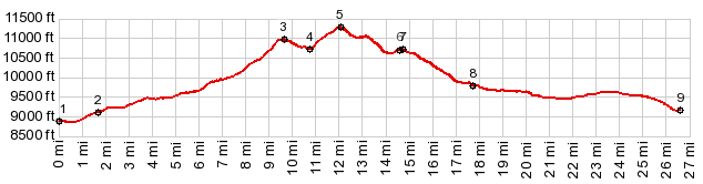
inspired housing. Dayride with this point as highest summit: PARTIALLY PAVED / UNPAVED ( < FR770
Highline Dr s(u) | Reno
Divide > ) Paradise Divide: Cement Creek Campgound
> Cement Creek Rd west > Co135 north >
Crested Butte > up Washington Gulch Rd >
Fr811 Washington Gulch Rd(shp) > up Fr743
<> short out and back to wilderness boundary
towards Yule Pass > Paradise Basin >
Schofield Pass(shp) > down CR317 > Mount
Crested Butte > Crested Butte > Co135 south
> Cement Creek Rd east back to starting point:
50.7miles with 4580ft of climbing in 5:27hrs
(garmin etrex30 m5:18.6.18).
|
|
|
advertisement |
|
|
advertisement |