| |
| |
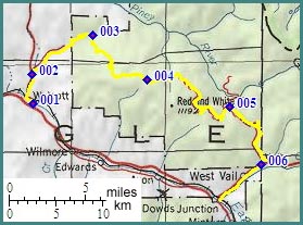
FR700 Red Sandstone Rd s(u)
I used to think that this was the
best way over Muddy
Divide. It still is a route over Muddy Divide.
But this road goes much higher. And since then I
found evidence of another route down Muddy Pass,
that does not require an extra 2000ft of climbing.
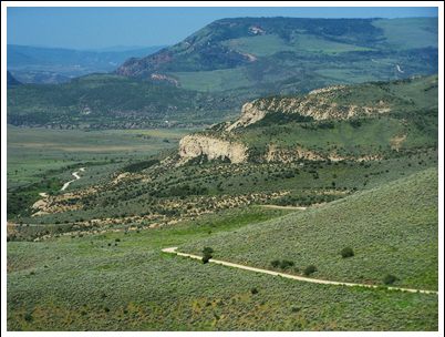
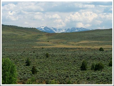
The ridge crossed by the FR700 Red Sandstone Rode
marks the transition between the dry rangelands of
the western slope and the alpine crest of the
Rockies, and offers great views onto the Gore
Range.
The road climbs in wide meanders up to the
treeline. The word "treeline" means the opposite
than to the east in the central Rockies. Here It
signifies where the forest on top of the plateau
starts. But before the road gets into the trees,
it crosses an endless meadow speckled with yellow
wild flowers in June, and also crosses "Muddy
Pass", also called "Muddy Divide" or "Muddy Creek
Pass" as Marshall Spraque calls it in the "The
Great Gates". From here a rough trail descends
north into the Piney River drainage. But this road has just started its climb. For now
the views are over on the west side. A signed
intersection on offers an alternate route to get
to the east side of this ridge on FR730 Red and
White Road. It's surface is rougher than FR700.
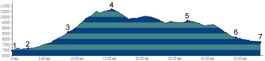
The slope ahead on FR700 is more variable now and
goes over its steepest sections. It created a deep
urge in me to walk now and then. In deep forest
the road rounds a wooded knoll near another muddy
pond called "Horse Pond". This seems to be the
top. However the road starts climbing again after
a short drop. After that nobody can say exactly
where the top is without an altimeter.
From East. (described
downwards). The descend delivers a hundred views
of the same subject, though each viewing angle has
its own charm. The subject is the sharpest peaks
of the Gore Range, including Mount Powell and
Eagle's Nest Peak. At first the range is seen
truncated by meadows of wildflowers and lines of
tall standing pines. The closer the bottom comes,
the more the view also opens up into the Piney
River Valley. Where FR700 meets up with the main road curving
through the Piney Valley. It is a major
intersection, relatively speaking: a parking lot
for the Lost Lake Trailhead. FR730 Red and White
Road rejoins the main route here also. Rolling
onwards, a few seconds later, signs that the end
is near are undeniable. The opposite slope
contains ski run clear cuts. Vail cannot be far,
but the road has a few more switchbacks planned. Finding the turnoff up to here (heading east) on
the Vail side is as follows. Past West Vail, on
the North Frontage Road you pass the two Vail
supermarkets: City Market and Saveway. A few miles
further up there is sign on the Interstate saying
"Colorado Ski Museum next exit, Gerald R Ford
Park". Excactly at this spot. Red Sandstone Rd
turns up into the wealthy Vail Hills, becoming
Potato Patch Drive. At a switchback the unpaved
Piney Road takes to the hills above. Dayrides ( < FR102C
Cooper Loop s(u) | McCord Pass >
)
|
|
|
advertisement |
|
|
advertisement |