| |
|
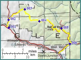
1.(6950ft,mile00) START-END WEST: Walcott: jct Co133-US6
2.(7120ft,mile03) profile turns right up dirt road following Muddy Creek
3.(8625ft,mile09) Muddy Pass; two other approaches on less traveled double tracks join from left
4.(10675ft,mile16) TOP: point of highest elevation
5.(9650ft,mile27) dirt road to Piney Crossing campground joins from left
6.(8130ft,mile35) junction with US6; profle continues downhill to right on pavement and biketrails
7.(7730ft,mile38) START-END EAST: Dowds Junction