| |
| |
FR700 Chimney Rock s(u)
Some continental divide crossings
are celebrated goals. There are two crossings in
the Rabbit Ears Range, east of Muddy Pass,
that arene't even marked on top. This is the
sllightly higher of the two (the other one is FR103
Chimney Rock Rd(sh) ). The scenic attraction
here has nothing to do with the continental
divide, but with various rock plug structures on
the south side - and I am also impressed each time
I enter North Park, the high plateau with its ring
of mountains. The right clouds help.
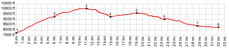
The entire climb is on good dirt road without any
washboard surface (July 15), and you could divide
it into two parts. The first one seems a little
steeper, higher and takes a little longer. The
road climbs, winding back and forth across the
sage covered mountain. Along the way it crosses
into ranch land, where many organically selfguided
hamburger generators are encounterd on the way up.
From the last switchback the road below appears
like a single endless spaghetti. For the second part of the climb, the road enters
forest for the most part. It crosses back into
state land, then into National Forest land. A
trail to "Indian Pass" takes off to the east just
after the road crosses into National Forest land.
Along the road there are several more fine views
of a rock structure, that seems to be plugging up
the top of the mountain, like the cork on a wine
bottle. That must be Chimney Rock. Looking around
from this higher, improved vatage point, several
of these rock plugs can be identified in the
surrounding hills, amongst they the most easily
idetifiable of them, Rabbit Ears Mountain.
I pass the jct with FR700. While FR103 descends
down Indian Creek, this profile follows FR700 just
a little higher. The road is noticably less
traveled for the next 5 miles, but smooth, and
nothing impedes the workout on the bike - the same
way as it would be on a paved road. Soon after the
descision is made to follow FR700, comes the
turnoff to FR104 on the right. Maps show this road
climb to a higher eleation and then dead end. FR700 crosses the continental divide, without a
sign or any other notice and then climbs a little
higher. The summit is not really noticable without
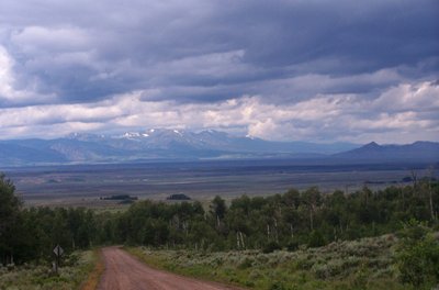
an altimeter.  From North. (described
downwards) Through the trees the Mount Circle area
in the Park Range can be made out, evidence that I
am getting around the mountain. But it is not good
enough for a picture. The next five miles are
apparently not traveled very much. Otherwise the
trees across the road would have been removed, by
a traveler. With the bike there is no problem
getting around them. After several miles the road improves, and a
parked trailer in a camping spot is evidence, that
the road is passable by everybody. If there is any
doubt left, it becomes clear now that this is a
long, curving forest travers. Meanders and curves
are not there overcome elevation but to survey the
forest and provide access to it. Countless trees
are marked with a blue stripe. The pine beetle has
devastated them, and they will be burned. The road passes, what must be one of the most
peaceful trailheads in the state. On one side you
can climb Aprapaho Ridge in 5 miles, on the other
side Hyannis Peak. Shortly after that the road
seems to reach a second inconspicuous summit
point. The elevation difference along FR700 is a
little more than the 300ft, but I can't find a
starting point that is 500ft below the summit. So
I won't count it. As the general direction of the meanders average
out to a northerly direction, landmarks start to
be labeled with signs: Bundy Park: a meadow with
piles of trees that look like funeral pires,
waiting to be burned. This is when the previousely
picturesque dark clouds, show what they have in
them and open up their spigots of water, full
force. I pass two strange looking lakes, that seem
to steam in the new weather conditions. In front
of me is blue sky. But I am heading east and have
no chance of catching these clouds. At least I
imagine that they make the rain feel a little
drier. At the second lake I find a motor home
camper and seek shelter under his canopy, between
two ATVs and a picnic table. It is the only thing
resembling a roof for many miles. He gives me an
"okay" from the dry inside of his motor home. After putting on a spare shirt I carried along, I
shiver my way down the remaining road, passing
more odd looking lakes along the way. Finally the
road becomes straight as a demonstration chalk
drawing of a geometry teacher, as the road shoots
into North Park. Scenically this is at least the
best thing on this side. The last snow on the Park
Range shines through across all these miles from
the other side of the park, surrounded by dark
clouds, which I can now admire form the dry side
again. The profile ends where FR700 intersects
with Co14. There is another alternative that would
have intersected Co14 a little further west,
making the loop slightly shorter.  Dayride with this point as highest summit: ( < FR103
Chimney Rock s(u) | FR500 Red Dirt Park
- Hay Park > ) -------------------------no elevation
measured-------------------- same summit points : a short distance up
FR103, near US40 > up FR103 > FR700 >
FR700 Chimney Rock s(u) > Bundy Park and other
landmarks > Co14 south > Muddy Pass
> US40 south > back to starting point on
FR103: 60miles (mechanical odometer: m2:90.10.6) 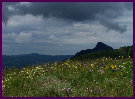
|

 In my my case the dark clouds make
a fine background to the brightly lit suflowers in
the foreground, while triangular mountain faces
below form regular triangles in the middle. It's a
beautiful ride.
In my my case the dark clouds make
a fine background to the brightly lit suflowers in
the foreground, while triangular mountain faces
below form regular triangles in the middle. It's a
beautiful ride.|
|
advertisement |
|
|
advertisement |