| |
| |
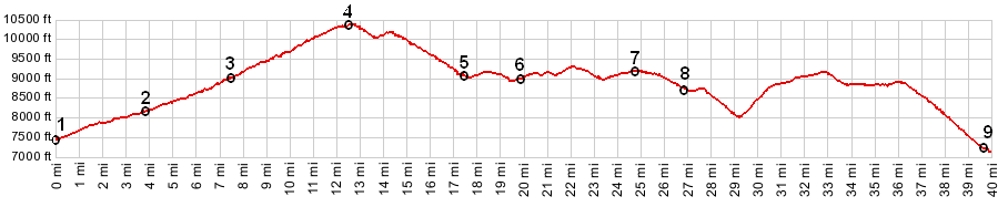
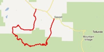
FR618 s(u)
This dirt road summit is located
in the forested foothills, south of the San Miguel
Range, part of the San Juan Mountains. There are
many views of the San Juan's westernmost sentinel
peak along the way, appropriately named Lone Cone.
But the scenic jewel along the way is Beaver Park
- such an ordinary name, such a sublime pace.
Unfortunately the forest service sold it off, but
the road through it still is public.
From East. The most direct
way to reach this summit is to ride up Fall Creek
Road from Co149. The first 3 miles are paved, and
the surface after that is smooth dirt, except for
short stretches that may have been graveled
recently (Sept 2011). Many spots in this deep
canyon are perpetually shaded and offer great
relief from summer heat. Just before you reach
"Lake of the Woods" the route turns right onto
FR618 and now climbs fairly steeply with improving
views onto Mount Wilson and El Diente Peak. As the
road curves around to head west, the view shed
changes to the north side, and there is nothing
there but little old "Little Cone", one of the
less complimentary names for a mountain in the
state. A potential biking route to the right over
a flank of this mountain (which was my orginal
goal for this ride) is shown on National Forest
Maps. But it crosses private land without public
access. As you cross the top of FR618 you catch
the first fast glimpse of Lone Cone Peak, the
western most peak in the San Juans mountains.
From West. There are still many more
vantage points on Lone Cone Peak to come. But
first the road descends to Beaver Park, on a
surface that is much rougher than the other side.
Traversing Beaver Park, and then climbing back out
of it, is in my opinion, the scenically most
interesting part of this profile. Paradoxically,
the area is in private ownership, surrounded by
national forest land, which contains remarkably
few potential campsites. The large grassy park is
backgrounded by peaks in the San Miguel Range. On
this portion of the ride new views of Lone Cone
Peak seem to be just about around every next turn,
and there are lots of turns here, as the road lies
on the landscape like a random piece of
shoestring. The profile continues on the most
direct way back, taking a right onto Beef Basin
Road. This route includes another substantial
steep climb, from Beaver Creek onto Specie Creek
Mesa. This is really a summit point in its own
right. The last part of the descend down to Co145
can again be fairly gravelly. One could avoid this
by making the ride longer instead and descending
to Norwood over Oak Hill Dayride PARTIALLY PAVED / UNPAVED
|
 Approaches
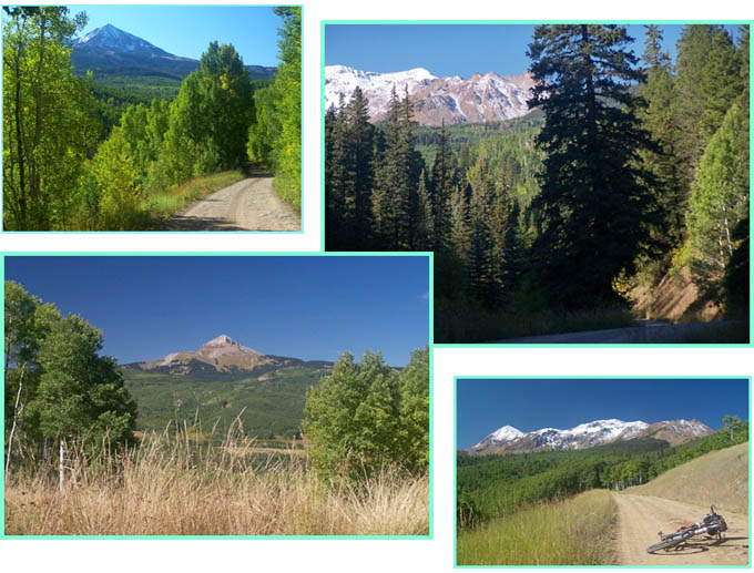
|
|
advertisement |
|
|
advertisement |