| |
| |
FR212 Radium - Toponas(sh)
The Central Rockies seem to take
a break in northern Colorado. The Front Range this
far north in the state still has snow covered
peaks in summer. But west of the Rawah Mountains,
the landscape is dominated by forested hills. But
there is a scenic marvel of a different type in
this area, a canyon - where the Colorado River
breaches the Gore Range. The road following the
canyon is known as Trough
Road Pass, and this dirt road climbs from
the canyon up far higher to connect with Gore Pass near its top.
The road is part of the Great Divide bike route,
which explains why I saw so many bikers racing
down the hill.
FR111 climbs above Radium, contouring to the
north, delivering picture perfect views of one of
the most spectacular rail canyons in Colorado. It
even descends again for just a little bit to allow
one more closer look. On the opposite side of the
canyon Cottonwood Peak and West Peak top the
panorama, reaching close to 11000ft. As the road climbs further to the east, you can
also make out Trough
Road Pass, and mountains that look like
gates to this canyon, to the east as well as to
the west. The road seems to reach a summit as it
changes its number from FR111 to FR212. But it
just turns away from the Colorado Canyon for a
short but steep descent to cross French Creek and
then resume climbing into more and more forested
hills. For how long they will be forested - I
don't know - it looks like the pine beetle got
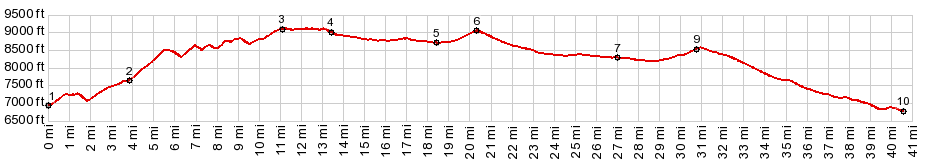
most of it. The road rolls higher and higher, just a few feet
with each rolling wave in the landscape. Lookng
north Cottonwood and West Peaks have taken their
lower place in the panorama, with the main peaks
of the Gore Range, Mount Powell and Eagle's Nest
Peak, standing out like large rocky islands in the
sea.
From North. (described
downwards) From the summit point, with the Gore
Range visible, the road rolls almost imperceptibly
down to join the paved Gore
Pass Road. In the final miles the road
passes a few private houses in the woods and many
pine beetle funeral pires. But you can tell you
are going downhill because the panorama to the
south is missing. Turing right up Gore Pass makes this point a
shoulder point towards a higher climb. Turning
left makes it a shoulder summit, even though the
wide straight, in comparison to what lies behind -
boring - road reaches one more point within 100ft
of the summit elevation before the descend starts
for real. The ride back down to the Colorado River
includes two more summit points, one before
reaching Tonopas, and a second after leaving
Tonopas. Dayride with this point as highest summit: PARTIALLY PAVED / UNPAVED ( < McCord Pass
| FR250
Rock Creek s(u) > ) |
|
|
advertisement |
|
|
advertisement |