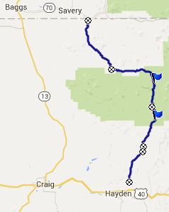
FR150 Hayden - Californa
Park s(u)
FR150 is a long ranch road, connecting Hayden
with the collection of houses that make up
Savery, Wyoming. On its way it crosses two
summits, that connect large grassy parks - a
real rancher's paradise. The profile goes over
both summits and this is the higher of the two.
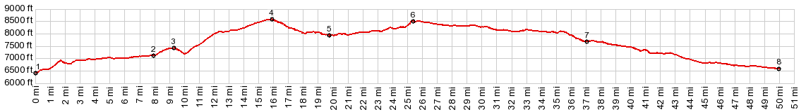 |
1.(mile00.0,6420ft)
START-SOUTH: jct FR150-CFR70, north east
of Hayden
2.(07.9mile,7110ft) jct with CR56 over the
ridge is on right
3.(09.3m,7410ft) intermediate high
pointmi_pix
4.(15.8m,8570ft) TOP: FR150 Hayden -
California Park s(u)
5.(19.7m,7940ft) lowest point on FR150 in
California Park
6.(25.3m,8490ft) TOP2: FR150 California
Park - Savery s(u)
7.(37.0m,7690ft) jct with CR1 on left,
going through to Co13
8.(50.0m,6580ft) START-END NORTH: Salt
Creek Crossing, just south of jct
FR150-Co129, south of Slater, Wy.
|
 Approaches Approaches
From North. When CR80
branches off from CR70, north of Hayden, travel by
bicycle slows down considerably. Climbing steeply
on a gravel surface, is just slow and labor
intensive. But looking back the Yampa River with
its rich glade of trees on both sides helps to at
least imagine coolness. The Flattops behind in the
distance also still have some snow on them.
But the initial torture really does not last long.
After that comes a fast section over rolling
hills, slanting upwards. There is one more
descent, not quite big enough to count as a
separate summit, and finally the green waves of
ranching country show the first signs of
transition to a cool aspen and evergreen forest.
The road reaches a summit shortly after finally
entering national forest land, on a straight
stretch in the forest. A big parking lot is
organized around public land informational signs.
But all the signs are blank
From South. I think
this side is much more attractive. A few
descending switchbacks give rest and provide an
introduction for the landscape of geometric blocks
ahead, in California Park.
A Ride with this point as intermediate summit
is on page: FR42
Mill Creek Rd s(u)
|