| |
|
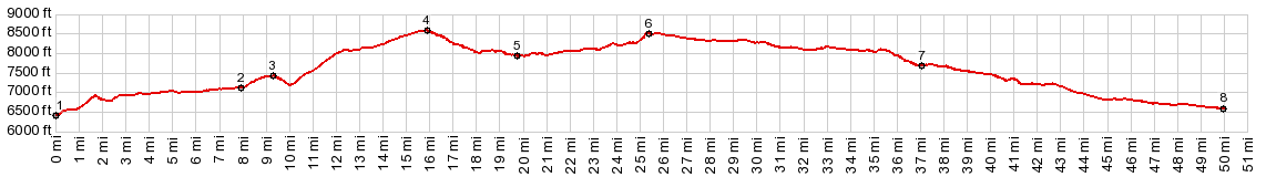
1.(mile00.0,6420ft) START-SOUTH: jct FR150-CFR70, north east of Hayden
2.(07.9mile,7110ft) jct with CR56 over the ridge is on right
3.(09.3m,7410ft) intermediate high pointmi_pix
4.(15.8m,8570ft) TOP: FR150 California - Hayden Park s(u)
5.(19.7m,7940ft) lowest point on FR150 in California Park
6.(25.3m,8490ft) TOP2: FR150 California Park - Slater s(u)
7.(37.0m,7690ft) jct with CR1 on left, going through to Co13
8.(50.0m,6580ft) START-END NORTH: Salt Creek Crossing, just south of jct FR150-Co129, south of Slater, Wy.
|