| |
| |
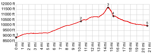
FR102C Cooper Loop s(u) This is another one of those
points, where I wonder if anybody ever
bothered to drag a bicycle to. It is a pretty
nice view from up here, but it involves a lot
of walking. To make a loop a section without
trails is involved.
From South. (described
downwards) But Lord behold, the GPS shows a road
not far down towards the west. A few hundred
feet down from the summit, the route skirts a
boulder field -the one place along the entire
upper route with great views. After that, it's a
walk without views through a moderate amount of
undergrowth. The recorded gps track joins the
North Tennessee Creek Rd at just about the same
point where the FR102C Cooper Loop began. Here
the profile heads south on the North Tennessee
Creek Rd until it meets Co24. At the junction
with the paved road one sign calls this road
"North Tennesee Pass" (the only reference
I have ever seen to such a thing), while the
sign facing the opposite direction sticks with
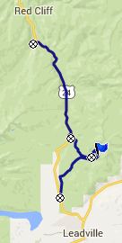
the "North Tennesee Creek Rd". Dayride PARTIALLY PAVED / UNPAVED / 0TRACK ( FR102 Cooper Loop s(u) , Tennesee Pass : 1.2miles from start of Homestake Rd > Homestake Rd east > Co24 south > Tennesee Pass(shp) > up FR101 > up FR102C > Fr102C Cooper Loop s(u) > down through forest to Tennesee Creek Rd > Tennesee Creek Rd south > Co24 north > Tennesee Pass > back to starting point on Homestake Rd: 38.4miles with 3700ft of climbing in 4:44hrs (Garmin etrex30: m5:15.6.20) |
||||||||||||||||||||||||||
|
|
advertisement |
|
|
advertisement |