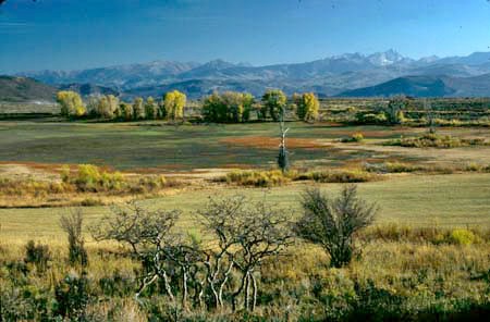
Cottonwood Pass

An abandoned highway is a beautiful thing. They come in two categories. Usually they parallel a newer road, on which traffic roars by unimpeded between utilitarian white lines. Meanwhile, off to the side, the crumbly pavement of the abandoned road is just perfect for a peaceful ride on a fat tire bike. Then their is the second category of an abandoned road. A route that follows an entirely different course than modern traffic, a road that lends itself to speculation of what might have been if this alternative route to circumnavigate a natural obstacle would have been chosen today.

This Cottonwood Pass is that kind of abandoned highway. It is an often forgotten connection to Aspen's Roaring Fork Valley from the northeast, bypassing Glenwood Canyon. The road is well used by locals. But chances are, that almost none of the hurried I70 travelers ever heard of it. The pass comes back into conscious memory when the main flow of Aspen bound traffic through Glenwood Canyon stops. This happens regularly through a forest fire, mudslide, or accident such as a spontaneously combusting truck hauling natural gas, caused by a driver who fell asleep at the wheel. All of these things have happened over the last two years, and the driver, familiar with local roads, all of a sudden remembers Cottonwood Pass. Luckily cyclists don't have to wait for such an "act of God" to explore this interesting ride.


click on profile for more detail
01.(6310ft,mile00) START-END NORTH: Gypsum
02.(6540ft,mile02) go right onto Cottonwood Pass road
03.(6760ft,mile05) dirt road on right goes to Blue Hill
04.(8610ft,mile05) another track on right to the Blue Hill area
05.(7660ft,mile08) yet another track on the right to Blue Hill area and a Glenwood Canyon overlook.
06.(7266ft,mile09) low point
07.(8280ft,mile13) TOP: Cottonwood Pass
08.(7190ft,mile19) profile continues on right to Co82 at Catherine store ; left will lead to Co82 in El Jebel
09.(7070ft,mile22) profile continues straight. But other options lead to Co82.
10.(6290ft,mile25) STOP-END SOUTH junction with Co82 at Catherine.

Approaches

From North. Hundreds of thousands of people travel the I70 corridor through Gypsum. Only a tiny fraction ever get to cast an eye on the stair step topography rising above the Colorado River towards the flattops to the north. This approach to Cottonwood Pass is ideal to get an overview of the Colorado Valley. The well used dirt road ( no crumbly pavement here ) leaves Gypsum along Valley road. The turnoff to Cottonwood Pass at point 2 is marked by a road sign. After the rectangular turns of the farming valley turned suburban real estate bubble disappear behind low forested ravines, the larger landscape picture also becomes clearer. The Sawatch Range terminates towards the east with with the abrupt shapes of large fish trunks. North of the Colorado Valley a geologic staircase rises from crumbly low badland steps to a rolling high plateau. The views become obscured by the ravines the road uses to wind to the top.

But the first top is not "the top". Known locally as "Blue Hill", it is also identified as a pass in "passes of Colorado". Given its definition that it divides Gypsum Creek from Cottonwood Creek the road does however not cross the divide. It touches it at the summit and continues down the same side of the water divide. The pass derives its name from its color that is in stark contrast to the red shales further down valley. On top of Blue Hill an interesting side trip leaves towards the right. See below. A steep short descent leads to a fenced ranching area. There a longer, more shallow ascent leads to the true summit surrounded by - you guessed it - Cottonwoods.

From South. A large scale map gives the impression that much of this approach is through public land. In recent years however, most of the land on this side of the approach is taking on the appearance of a subdivision containing very large parcels of land. There are many ways to approach the summit from this side. The profile shows the most direct route from the valley. After leaving the valley, views of the Elk Range behind Aspen become quite impressive, and at times you can even avoid the foreground of somebody's flaunting real estate. The picture below was taken on that option and predates the Roaring Fork housing boom.When connecting the pass with a circle through Glenwood Canyon, a more direct approach using unimproved roads north of Co82 is a more scenic option. For this option far views of Mount Scopris make up the scenery.


Sidetrip. From the top of Blue Hill, about 8 and a half miles from Gypsum, a double track trail leads to two viewpoints which are not only perfect vantage points onto the confluence of the Eagle and Colorado Rivers, but also the west entrance of Glenwood Canyon. This vantage point is right between what is and what might have been, as far as highways are concerned. See history section below.

Tours

Overnight Tour. Several routes between Dotsero and New Castle ( or Glenwood Springs ) lend themselves to overnight tours. The day from Dotsero over Cottonwood Pass to New Castle, also including the sidetrip described above, measured 68 miles with 5400 feet of elevation gain in 6.2 hours. The reverse direction was used to traverse the White River Plateau summit(u).


Dayrides. (paved+unpaved) Here is a long dayride that could also be done in two days: Gypsum > Crooked Creek Pass > El Jebel > Cottonwood Pass > Gypsum, 92 measured miles with onboard odometer (m1:87.10.05).

Cottonwood Pass can also be combined with the bikepath through Glenwood Canyon in a dayride: Glenwood Springs > Glenwood Canyon > Gypsum > Cottonwood Pass > Red Canyon road > Glenwood Springs: 68 miles, 4600ft climbing in 5.39 hours (m3:06.08.13).


History

A wagon road crossed this old highway already in 1883, only three years after Independence Pass was used to get supplies into Aspen mining camps.

Modern Highways With the opening of a feasible highway over Loveland Pass and Vail Pass in 1940 a direct westbound route through the state became feasible. It was at this time that Cottonwood Pass carried the Denver - Grand Junction traffic. But before the decade was over, US24 was designated to run through Glenwood Canyon instead, commencing a large construction project of a much different kind.

But Cottonwood Pass remained on the planning table as a major traffic artery. The pass was considered for improvement as a temporary highway, when US24 became I70 through the canyon. However local business interests were afraid that the temporary solution could be just a little bit too perfect. A paved highway over Cottonwood Pass would in effect cut off Glenwood Springs from the Denver - Aspen traffic, not a desirable goal for expensive Glenwood Springs Spa merchants. The fact that it would also save much gasoline was not so important. A positive sideeffect for today's cyclist is what is arguably the state's most fascinating canyon cycling route, the bike trail through Glenwood Canyon. Thank you - Glenwood Springs overpriced knick knack merchants.

Glenwood Canyon can be cycled with an extensive variety of tire sizes, from little girls pink colored tricycle 16 inch tires to sew ups on trendy pink-rose colored Pinarello thoroughbreds. Getting a road bike over Cottonwood Pass is also viable during dry conditions. But the sidetrip remains the territory of the supersize-me fat rubber. It would truly be a shame to wait until the next truck driver falls asleep in Glenwood Canyon and his tanker combusts spontaneously. Cottonwood Pass and especially the sidetrip up Blue Hill are worth exploring without a traffic accident reminding us of its presence.

If Cottonwood Pass had been developed as paved road, the present would look different. Glenwood Springs' role as a developing market place would be in doubt.(Dec/05). Today throngs of shoppers follow Glenwood Canyon to Glenwood Springs, but more importantly follow the Roaring Fork Valley to Glenwood Springs in order to shop the newly built businesses. These days it's the same scene as up and down the Front Range. A few token towers that look like italian rennaissance from 20 miles distance - but not from 5 miles distance - adorn the Big Box stores. They seem to call "come hither and spend your money". Once you come closer you realize that they are nothing but a cheap stage set. There is no need to distract potential shoppers with too much architectural detail, while they're still traversing the parking lot to the local Bed Shoe Bath Paradise.


back to Colorado Pass Tables Page


Copyright (C) 2003-2008 by Michael Fiebach - All Rights Reserved