| |
| |
Copper Gulch Divide
This is a fairly obscure, but
regularly traveled low crossing on the De Weese
Plateau, east of the Wet Mountain Valley. It is
listed in the book "Passes of Colorado". For those
who are not put off by the occasional dusty
stretch of dirt road, this is a great viewing
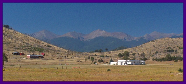
platform onto the Sangre de Cristo Range,
especially during "interesting cloud days". The
portion over the top is paved. But to make a loop
you have to negotiate a variety of surfaces.
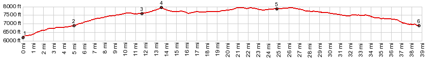
From South. (described
downwards) The viewing platform of this rolling
descend is by far the most interesting part of the
ride, during days when spectacular cloud displays
complement the linear beauty of the mountain
range. When it's hazy, the views may be
disappointing. On the map the road heads straight
as an arrow for Westclliff. But in reality it is
not so straight in an up and down sense - more
like a series of waves. The most direct way back
down to Co69 is via Reed Gulch CR29 and CR203. But
that option actually goes over a slightly higher
point. The turnoff to this option is the low point
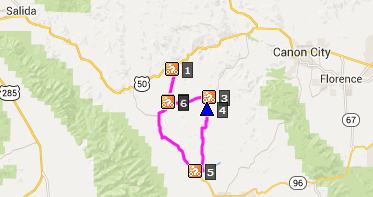
between points 4 and 5 at 7605ft. Rides with this point as highest summit: PARTIALLY PAVED / UNPAVED Copper Gulch Divide , CR255 Oak Grade Rd
(s(u)-sh?) , CR3 Temple Canyon Rd s(u)? :
just west of Sunset City > CR26 south >
Copper Gulch Divide > CR215 Copper Gulch Rd
south > Co69 south > Westcliffe > Co96
east > Silvercliffe > CR255 Oak Grade Rd
north > CR255 Oak Grade Rd s(u)? > Canyon
City possibly with detour > CR3 Temple Canyon
rd east > CR3 Temple Canyon Rd s(u)? > CR29
Copper Gulch Rd west back to starting point:
(m2:98.10.4) A Ride with this point as intermediate summit
is on pages: CR170 the
Pines Ranch(sh) 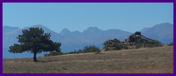
|
||||||||||||||||||||||||||||||||||||||||||||
|
|
advertisement |
|
|
advertisement |