| |
|
|
|
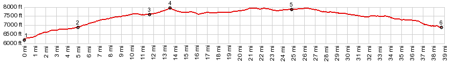
1.(mile00.0,6190ft) START-END NORTH1: jctUS50 - Co69 on Arkansas River
2.(mile05.0,6880ft)profile turns left on Gulch Rd
3.(mile11.7,7600ft)jct with Copper Gulch Rd, profile turns right
4.(mile13.6,7927ft)TOP: Copper Gulch Divide
5.(mile24.9,7860ft)profile turns north on Co69, north of Westcliffe
6.(mile38.8,6880ft)START-END NORTH2: Co69: jct with Gulch Rd, same as point 2
|
|