| |
| |
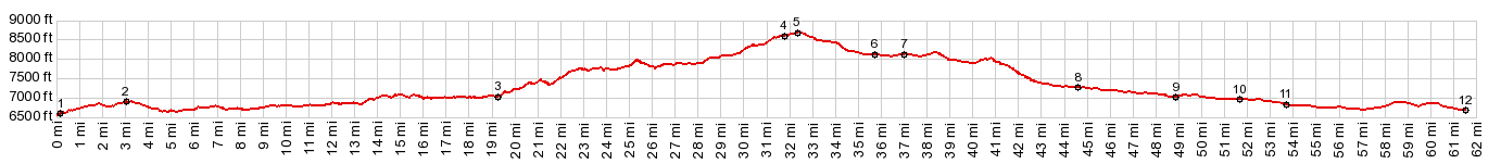
Columbine Pass
The nicest paved road ride from
Steamboat Springs just may be heading north to
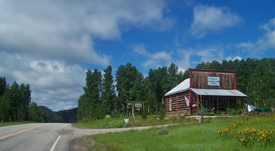
Columbine with its old store and cabins, located
above Hahn's Peak basin On the other side
the pavement ends about 200ft below the summit. So
that's why this road is in the "unpaved" category.
The name Columbine Pass is not very commonly used today. The designation is included in Ed and Gloria Helmuth's book "the passes of Colorado". They source it back to members of the Colorado Mountain Club, who identified it in the 1920s.
As I make my way up into the gentle hills, my
overwhelming impression is of being somewhere in
New England. Just look at all those wooden barns,
green fields, the small white church with the
wooden steeple - actually that "church" turns out
to be a church to education, an old school house.
The congregation of school children must have been
very small. - But then past Clark, most of the
traffic is gone, now the road has a shoulder, and
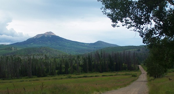
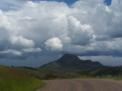
this large cone shaped mountain appears ahead.
Hahn's Peak is the number one landmark from both
sides, and unmistakable from any angle by its cone
shape. Steamboat Lake is the number one destination for
most traffic coming up here. The road leading
around the north end has several quiet access
points. It turns unpaved after a short distance
and continues down valley along the west side to
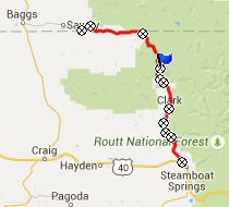
join back to CR129 in Clark. CR129 to Columbine Pass reaches a clearly defined saddle at a restored general store, with nearby cabins for rent, in what maps label as a town: Columbine.
From South. (also
described upwards) This approach appears
to be on the opposite side of the world from a ski
area. It starts in Wyoming. Steamboat not
only seems like long ways from here, it actually
is about 60 miles away. No sign at the turnoff
onto CR129 at point 2 mentions Steamboat Springs -
just the county road number 129. Countless ranches, safely separated from one
another by many miles of open ranch land, line the
road. Each ranch house has a different
architecture, and each one fits into the landscape
in a different way. The last house turns out to be
a extravagant mansion, built by some Hollywood
mogul. Well actually - no - it's another ranch.
The Three Forks Ranch just has a different look to
it. Immediately after leaving the hundreds of "no
trespassing - three forks" sings behind, the road
starts climbing in earnest. The increase in slope
feels larger than what the profile leads to
suspect. Soon after that the route crosses into
National Forest land. And with that come the
actual trees in the forest, and also less graveled
but more rutted road conditions, which are really
better for riding a mountain bike. Parts of this
road are on a surface of dark ash of sorts, that
turns into extremely sticky mud with the slightest
of rainfall. - Not very pleasant on a bicycle. Before the final climb the road
enters another spacious park and Hahn's Peak
points the way, together with old acquaintance
from the other side: Nipple Mountain. Hahn's Peak
appears a lot higher from this side. But maybe it
is just, that the mud was deeper on this side.
With less energy the apparent dimensions of the
landscape increase, and the mud on the wheels rob
a lot of energy. Luckily it stops raining before I
reach the top, and by the time I'm back it has all
dried to dust, that breaks off like crusted coca
powder with the nudge of a finger. A ride with this point as intermediate summit is on page: FR42 Mill Creek Rd s(u)
|
|
|
advertisement |
|
|
advertisement |