| |
|
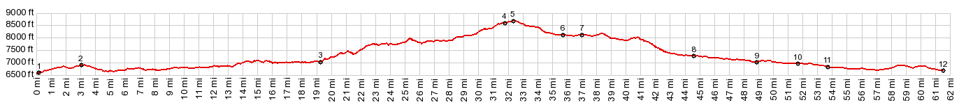
01.(mile00.0,6600ft) START-END NORTH: jct Wy70 - CR123,near Slater Wy.
02.(mile00.2,6600ft) profile turns left onto paved CR129
03.(mile19.3,6990ft) road passes entrance to Three Forks Ranch and starts climbing more steeply
04.(mile31.7,8550ft) jct with FS550 on left
05.(mile32.4,8680ft) TOP: Columbine Pass
06.(mile35.7,8120ft) jct with CR62 and closest entrance to Steamboat Lake on left
07.(mile37.1,8140ft) jct with FR13 in town Hahn's Peak
08.(mile44.6,7270ft) jct with CR62 and Great Divide bike route from CR42 Mill Creek Rd s(u)
09.(mile49.0,6970ft) jct with CR56 on right
10.(mile51.8,6950ft) jct with CR54 on right
11.(mile53.8,6820ft) jct with CR52e on right
12.(mile61.5,6680ft) START-END SOUTH: jct Elk River Rd - US40, just west of Steamboat Springs
|