| |
| |
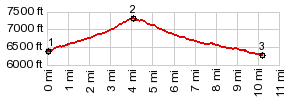
CR37 - CR1A Mc Coy
Gulch(sh)
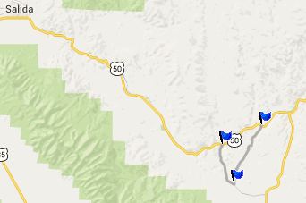
Wherever Dakota Sandstone crops
out along the Front Range of Colorado, the scenic
splendor of craggy foothills are the result. Take
the lower Platte River Canyon as an example. Here
is another example: the Dakota sandstone outcrops
south of Cotopaxi, Arkansas Canyon area. This
small dirt road summit leads through this area.
The highest point is located at its junction with
CR1A, just
north of its summit.
From East. (described
downwards). It's probably best to traverse this
road in the downward direction, because of a few
sandy stretches near the bottom. Riding this
downwards I only had to get off the bike twice for
very short periods. Why ride it at all ? - Because
of an - in my opinion - the extremely scenic 2
miles at the top, where the road negotiates
between several monuments of billowing sandstone,
that make a perfect foreground for three different
subjects: the Sangre de Christo Range to the
south, the Sawatch Range to the far west, and also
more rugged foothills around the Arkansas Canyon
to the east. This is a side of the landscape, that
you would never imagine exists, if you limit
travel to the paved CR1A from Cotopaxi to
Westcliffe. A Dayride with this point as
intermediate summit is on page: CR169 Waugh
Mountain s(u)
|
|
|
advertisement |
|
|
advertisement |