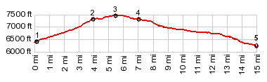
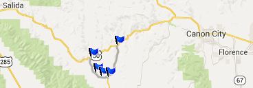
CR1-A Cotopaxi(sh)
Both of these approaches are ways to reach the northern end
of the Wet Mountain Valley from the Arkansas Canyon. This
little shoulder summit connects them together. It is a
shoulder summit because south of the "summit
point", the road keeps on climbing ever so gently 
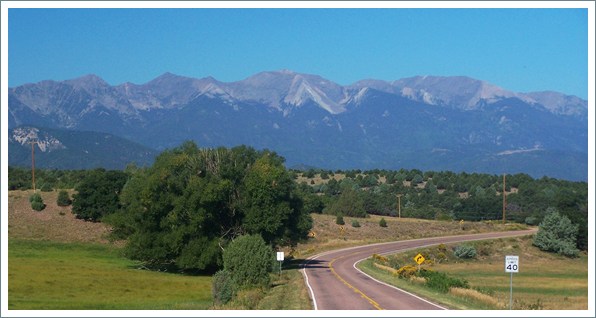
into
the Wet Mountain Valley. The views along this shoulder
summit ride are a precursor to the wide sweeping panoramas
in the Wet Mountain Valley.
 |
1.(6370ft,00.0m)START-END
WEST: Texas Creek: jct CR1A-US50)
2.(7310ft,03.9m)Mc Coy Gulch Rd takes off on left
3.(7450ft,05.5m)TOP: CR1A-Cotopaxi(sh)
4.(7300ft,07.0m)jct with Co69. Profile turns left back
to Arkansas River
5.(6190ft,15.0m)START-END EAST: jct Co69-US50 on
Arkansas River |
Approaches
From North. The profile starts at the
only paved intersection in Cotopaxi. Going in a southerly
direction, the small road leaves behind the traffic and climbs
between the forested lower slopes of the Sangre de Cristo
mountains, and the Dakota sandstone formation on the other side.
From this vantage point you see nothing of the erosinal shapes
on the opposite side in McCoy
Gulch.
Approaching the top is a short steep section with some nice
views of the pyramid shaped northern peaks in the Sangre de
Cristo Range. A dirt road into Mc Coy Gulch near the top shows
off the erosion monuments much better than you would ever
suspect by just cycling on CR1-A. The exact top is practically
impossible to determine, because the road rolls over several
point that are within a few feet in elevation. One of these
points has another county road branching off to a ranch
entrance.
From South. (also described
upwards) Co69 also climbs from the Arkansas Valley, direction
Westcliff. It leaves Co69 from a point 7 miles further down
canyon. This road is even shallower and follows a dry forested
ravine. The road crosses several dry streams. The turnoff onto
CR1-A is only 100-200ft below the summit of CR1-A, and Co69
keeps on climbing ever so gently direction Westcliffe, with
access to much higher summit points.
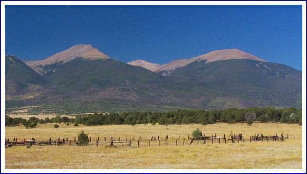
Dayride with this point as highest summit
COMPLETELY PAVED:
(< CR169 Waugh
Mountain s(u) | FR401
Deer Peak s(u) >)
CR1A Cotopaxi(sh) , additional out and back: Mc Coy Gulch
> CR1A north > Cotopaxi <> out and back to Salida on
US50 >> US50 east > up Co69 > CR1A Cotopaxi(sh)
> back to starting point: 74.1miles with 2610ft of climbing
in 5:19hrs (VDO MC1.0 r5:14.9.14)
CR1A-Cotopaxi(sh)
Highest Point: 7450ft
|
Western Approach:
|
climb |
over distance
|
Texas Creek: jct CR1A-US50 (6370ft)
|
1080ft |
5miles |
Eastern Approach:
|
|
|
jct Co69-US50 on Arkansas River
(6190ft)
|
1260ft |
9+1/2miles
|
|