| |
| |
BLM 7058 Corcoran Peak
summit(u)
 De Beque
is not exactly like Fruita or Moab, when you walk
down Main Street. Here the lunch option consists
of sitting on a bench in front of the single small
grocery store munching on a hopefully, no longer
frozen burrito. There are no trendy restaurants,
just idling pickup trucks across the street at the
post office. Their cars keep on idling away
gasoline, while the drivers are inside, catching
up on the local news. But for this ride de Beque
is too early as lunch stop. So let's assume we had
breakfast instead and are ready to go, and now
turn our attention to the scenery surrounding this
town. And now there are similarities between De
Beque and the formerly mentioned mountain biking
destination towns. De Beque
is not exactly like Fruita or Moab, when you walk
down Main Street. Here the lunch option consists
of sitting on a bench in front of the single small
grocery store munching on a hopefully, no longer
frozen burrito. There are no trendy restaurants,
just idling pickup trucks across the street at the
post office. Their cars keep on idling away
gasoline, while the drivers are inside, catching
up on the local news. But for this ride de Beque
is too early as lunch stop. So let's assume we had
breakfast instead and are ready to go, and now
turn our attention to the scenery surrounding this
town. And now there are similarities between De
Beque and the formerly mentioned mountain biking
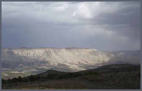
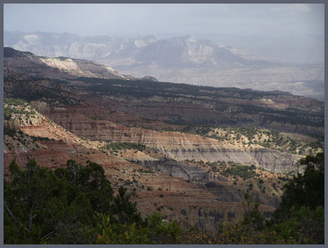
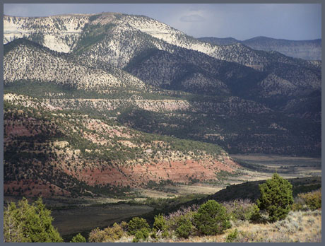
destination towns.To cut to the end, the ride around Corcoran Peak is my favorite Colorado Book Cliffs loop. It contains a short ridge section with far views onto multi colored cliffs and candle like rock formations. A quickly traversable double track trail follows close to the crest of South Shale Ridge and completes the panoramic experience.
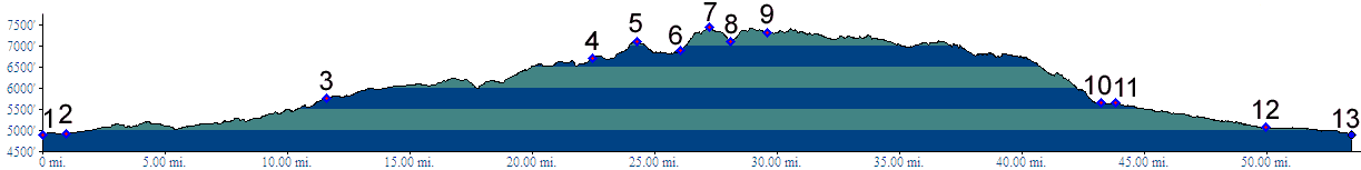
Approaches From South-West. The profile shows the
approach from de Beque to the top of Wild Horse
Trail summit(u). See that page for a
description to point 6. From there a steep double
track trail turns right up towards Corcoran Peak.
After the view shed changes towards South Dry
Creek, various forks allow a quick descent north.
But this profile stays on the ridge as much as
possible. After a short section allowing views
into the Colorado Valley, the through going route
stays on the north side of the ridge with various
spurs climbing to points on the ridge itself. The
surface soon improves as the road picks up another
more maintained route climbing up from the
valley.
From North. (described downwards): When the distinctive shape of Mount Logan comes back into view, you at least know you are heading in the right direction, on the average, even if repeated curves carve deep into the large bowls of South Shale Ridge. The repeated ups and downs along the ridge seem more tiring than the approach climb. But the net elevation change averages to 0. The route finally descends when it crosses a burn area where trees stick out like a black match stick forest. The route descends to the valley and picks up South Shale Road, which is also the principal approach for the Wild Horse Trail summit(u). When you think you're past all the small rolling hills, still more of them turn up while crossing dry washes. When traversing this approach in the uphill
direction, the turnoff from the valley onto
BLM7058 is easy to miss. Even from a slow moving
bicycle it looks just like any of the many dead
ends going to gas wells. Going uphill on Dry Creek
Road, take the South Dry Creek Fork option. The
road makes two 90 degree turns to get around a
guest ranch with two old carriages on display.
Immediately afterwards, take the track descending
to cross Dry Creek. If you look closely there may
also be a downed sign stating Horse Trail mile 35,
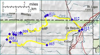
and BLM7058. Dayride with this point as highest summit: PARTIALLY PAVED / UNPAVED BLM7958 Corcoran Peak s(u) : de Beque I70
exit > Wild Horse Trail summit(shp) > up
South-West approach to BLM7058 Corcoran Peak s(u)
> BLM7058 Corcoran Peak s(u) > down North
approach > Dry Creek Road > back to
the starting point: 57 miles with 6400ft of
climbing in 6:2 hours, using a VDO MC1.0 cycle
computer.(m3:7.09.30)
|
|
|
advertisement |
|
|
advertisement |