| |
|
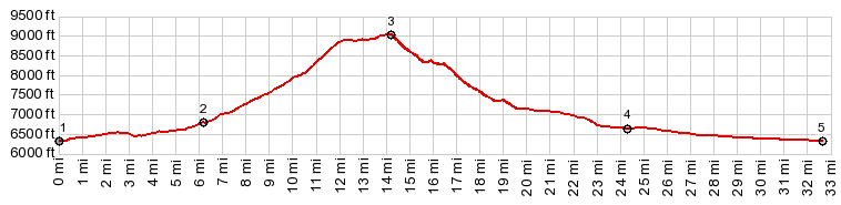
1.START-END EAST:jct US278 - Green Mtn Rd
2.route splits into eastern and western part of loop road
3.TOP,jct Green Mtn Rd - Mine Acess - road to Wild Horse Point, 9020ft
4.route joins Crook's Gap Rd
5.START-END WEST:jct US278 - Crook's Gap SRd
|
|
1.START-END EAST:jct US278 - Green Mtn Rd 2.route splits into eastern and western part of loop road 3.TOP,jct Green Mtn Rd - Mine Acess - road to Wild Horse Point, 9020ft 4.route joins Crook's Gap Rd 5.START-END WEST:jct US278 - Crook's Gap SRd
|