| |
|
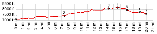
1.(mile00.0,7090ft) START-END NORTH: road crosses Muddy Creek and connects with Bridger Pass profile
2.(mile07.5,7420ft)Cow Creek (or Butte) turnoff on right, just before road doubles back to north and starts climbing
3.(mile14.3,8100ft)road to Rendle Butte joins from right
4.(mile15.7,8170ft)TOP
5.(mile17.0,7970ft)low point, before profile turns left on McCarty Canyon Rd
6.(mile19.0,7760ft)intermediate high point, south of Rawlins Reservoir
7.(mile20.0,7600ft)START-END SOUTH: low point at Rawlins Reservoir
|