| |
|
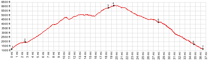
1.(1160ft,mile00.0)START-END NORTH: jct S Lakeshore Rd - Shady Pass Rd, just west of Twenty Five Mile Creek State Park on Lake Chelan
2.(2000ft,mile02.6)profile goes left onto Slide Ridge Rd
3.(5880ft,mile18.4)jct with FR5503 to Stormy Mtn on right
4.(6120ft,mile19.4)TOP: route crosses pass, opening viewshed to west
5.(4220ft,mile28.0)profile stays left at this junction
6.(1720ft,mile34.6)dirt road terminates onto Wa971; profile goes left
7.(1210ft,mile36.5)START-END SOUTH: low point on S Lakeshore Road
|
|
-