| |
|
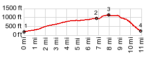
1.(00.0m,0190ft)START-END WEST:jct US20 - Baker Lake Rd
2.(06.8m,940ft)profile turns right onto Burpee Hill Rd
3.(08.0m,1140ft)TOP
4.(11.0m,0230ft)START-END EAST:jct US20 - Burpee Hill Rd in Concrete
|
|
1.(00.0m,0190ft)START-END WEST:jct US20 - Baker Lake Rd 2.(06.8m,940ft)profile turns right onto Burpee Hill Rd 3.(08.0m,1140ft)TOP 4.(11.0m,0230ft)START-END EAST:jct US20 - Burpee Hill Rd in Concrete
|